Rain and warmer temperatures on tap for the next few days
MACON, Georgia. (41NBC/WMGT) – As a warm front lifts to the north this afternoon, temperatures will be on the rise, as will rain chances.
TODAY.
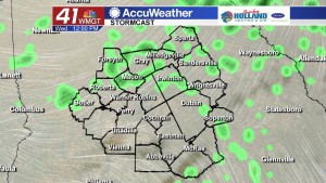
The wedge of cool air that kept up in the upper 40’s and low 50’s yesterday afternoon continues to break down, and with an approaching warm front, temperatures will be in the 60’s and 70’s this afternoon. We continue to be stuck in a wet weather pattern, and that is going to allow for isolated showers to move through our area once again today. I have put in a 30% rain chance for this afternoon and evening. As for overnight temperatures, with the warm front moving to our north and bringing in a southerly wind we will see low temperatures running in the mid-to-upper 50’s while still dealing with some lingering isolated showers.
TOMORROW.
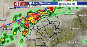
Rain coverage increases tomorrow with an approaching cold front. We will start off the day with an overcast sky and isolated showers, but by the time we get into the afternoon and evening hours we will be dealing with scattered showers. Severe weather is not in the forecast for tomorrow, but thunderstorms will be present as well so you can expect to hear a few rumbles of thunder on your Thursday. It will be another warm night across Middle Georgia as temperatures will be running in the low 60’s, which is where we should be for afternoon high temperatures!
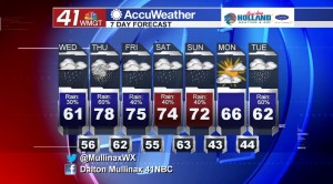
WEEKEND.
The weekend does not look to be a total washout, but scattered showers will be present throughout the entire weekend. A cold front moves through overnight on Saturday night and into Sunday morning which will clear us out by Sunday afternoon.
 Meteorologist Dalton Mullinax on Facebook (Dalton Mullinax 41NBC) and Twitter (@MullinaxWX) for weather updates throughout the day. You can also watch his forecasts Monday through Friday on 41NBC News at Daybreak (5-7 a.m.) and 41Today (11 a.m.).


Leave a Reply