
Rain showers leads to much colder temps to end the week
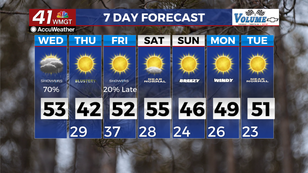
MACON, Georgia (41NBC/WMGT) – A strong trough diving south from Canada impacts Georgia today. Lift ahead of the trough will generate some light rain in Middle Georgia this morning, 


 with additional rain moving in from the northwest with the cold front this afternoon. Since any rain will be light, the main story will be the cold temperatures and the potential for snowflakes in the mountains. Any flakes should be limited to the high elevations of the mountains. This same period of time expect rapid drying which will limit the potential for any impactful snow rates. Ground and road temperatures should be above freezing in most areas before 1 AM, this should hinder any accumulations. Breezy northwest winds and temperatures in the mid 20s will push wind chills into the teens across north Georgia Thursday morning. Looking ahead, the majority of models support a dry forecast, with cold air surging in at the start of next week. As we have seen there are a few cautionaries that produce snowfall, but others account for less. As far as the odds of an impactful wintry weather this weekend, it remains very low. If any wintry weather does occur this weekend, it would most likely occur Friday night into Saturday, as a narrow band of moisture moves through the region. The intensity of this band has increased slightly over the last 24 hours. Therefore, we have mentioned a small chance 20 percent for Friday night. Some additional light precipitation could develop over the weekend as a couple weak shortwaves rotate through the base of a larger trough over the Eastern U.S. Confidence in the exact timing, track or strength of any of these features remains very low at this time, thus our forecast remains dry. The forecast for Sunday has trended slightly colder over the last 24 hours. We now anticipate morning wind chills in the teens on Sunday to go along with similar numbers for Monday and Tuesday mornings.