


Rain showers hang around for next several days
MACON, Georgia. (41NBC/WMGT) – After a mostly sunny sky yesterday afternoon we will see a return of clouds and rain to Middle Georgia today through the end of the weekend.
TODAY.
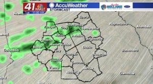

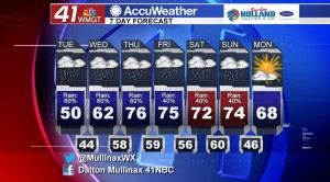
An area of high pressure off to our northeast has provided a “wedge” of cool air in Middle Georgia, and that is going to keep us well below normal afternoon high temperatures this afternoon. Under a mostly cloudy sky, we will be dodging scattered showers all afternoon as our wet weather pattern continues. Afternoon high temperatures will struggle to make it out of the upper 40’s due to the reinforcement of cooler air being brought in by a northeasterly wind. Sustained winds will come in at ten to fifteen miles per hour, but gusts could check in as high as twenty-five miles per hour. Overcast skies will continue into the evening hours where rain showers will become more isolated. Temperatures will be running in the mid-40’s.
TOMORROW.
There will be more of the same on Wednesday afternoon in the way of rain, but temperatures will be much warmer as the wedge of cool air breaks down and we see a return of more seasonal temperatures to our area. Overnight temperatures will be running nearly 20° above average as a mostly cloudy sky will keep things warm in the upper 50’s.
REST OF WEEK.
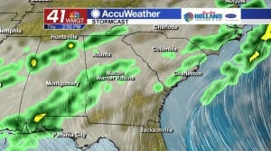
Thursday and Friday we will be dealing once again with rain showers across Middle Georgia. Temperatures will be on the rise as well as temperatures soar into the middle 70’s. Today through Friday I am expecting most areas across our area to receive right around an inch of rain.
 Meteorologist Dalton Mullinax on Facebook (Dalton Mullinax 41NBC) and Twitter (@MullinaxWX) for weather updates throughout the day. You can also watch his forecasts Monday through Friday on 41NBC News at Daybreak (5-7 a.m.) and 41Today (11 a.m.).

Leave a Reply