
Rain returns tomorrow evening
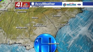
MACON, Georgia. (41NBC/WMGT) – The high pressure center that has kept us dry to start the week will move away and make a path for another cold front to sweep through Middle Georgia bringing showers to the region late tomorrow evening.
TODAY.
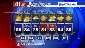
More sunshine is on the way this afternoon as a ridge of high pressure keeps us dry for another day. The average high temperature for this time of year is 79°, but we will once again blow past that this afternoon. I am forecasting afternoon high temperatures to climb into the middle and upper 80’s across our region. We will continue to see middle and high level clouds stream in from the west throughout the afternoon and evening hours, but a mostly clear sky is still expected overnight with temperatures falling into the middle and upper 50’s.
TOMORROW.
We start the morning off on the mild side before warmer weather returns during the afternoon hours. Temperatures will top out in the low to mid 80’s under a partly sunny sky. We will stay dry through the afternoon before rain chances increase in the evening and overnight hours ahead of a cold front. Rain chances Thursday evening are running at just about 30%.
THROUGH THE WEEKEND.
Rain chances increase to 60% on Friday during the first half of the day before clearing out just in time for the weekend. Friday night through Sunday morning will be dry. A weather disturbance will move through the region during the afternoon on Sunday bringing an isolated rain chance to Middle Georgia, but that appears to be it in the way of rain for our weekend. We will stay dry and warm as we head into the month of May.
 Follow Meteorologist Dalton Mullinax on Facebook (Dalton Mullinax 41NBC) and Twitter (@MullinaxWX) for weather updates throughout the day. You can also watch his forecasts Monday through Friday on 41NBC News at Daybreak (5-7 a.m.) and 41Today (11 a.m.).


Leave a Reply