

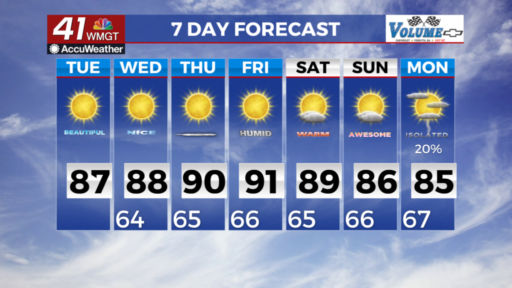
Rain chances very few and far
MACON, Georgia (41NBC/WMGT) – A coastal low will continue to enjoy its life along the coast of the Carolinas today. Over the last 24 hours a weak shortwave rotating around a parent low has 


 become increasingly apparent. As this wave slides southward through the southern Appalachians this afternoon it will lift and combine with diurnal heating to support isolated thunderstorm development. Models favor isolated activity over the mountains of northeast Georgia by 1 PM, with limited activity expanding to other parts of north Georgia between 1 PM and 9 PM. Afternoon dewpoints near 60 will limit the amount of instability for storms to work with this afternoon. The odds of severe weather are very low, however, there may be a couple of storms that produce wind gusts of 30 to 40 mph. Although the forecast has been towards greater rain chances today, significant rainfall remains unlikely in north Georgia. Our forecast rain chances peak near 30% in the mountains and are 20% or less for other areas along and north of I-20. Therefore most locations won’t see any rainfall today, and where rainfall does occur, a best case scenario is probably a half an inch of rain. Cloud cover should help keep most of north Georgia in the mid to low 80s this afternoon, while Middle Georgia will see highs in the upper 80s. A couple of additional weak shortwaves could rotate through north Georgia tonight. These features will lack the aid of daytime heating, but they could still prove sufficient to produce some light rainfall. The area most likely to see light rain should extend from the northwest Georgia/Alabama border down into Atlanta metro. Rain chances should peak between 2 AM and 8 AM. Lightning is unlikely due to a lack of instability overnight.

