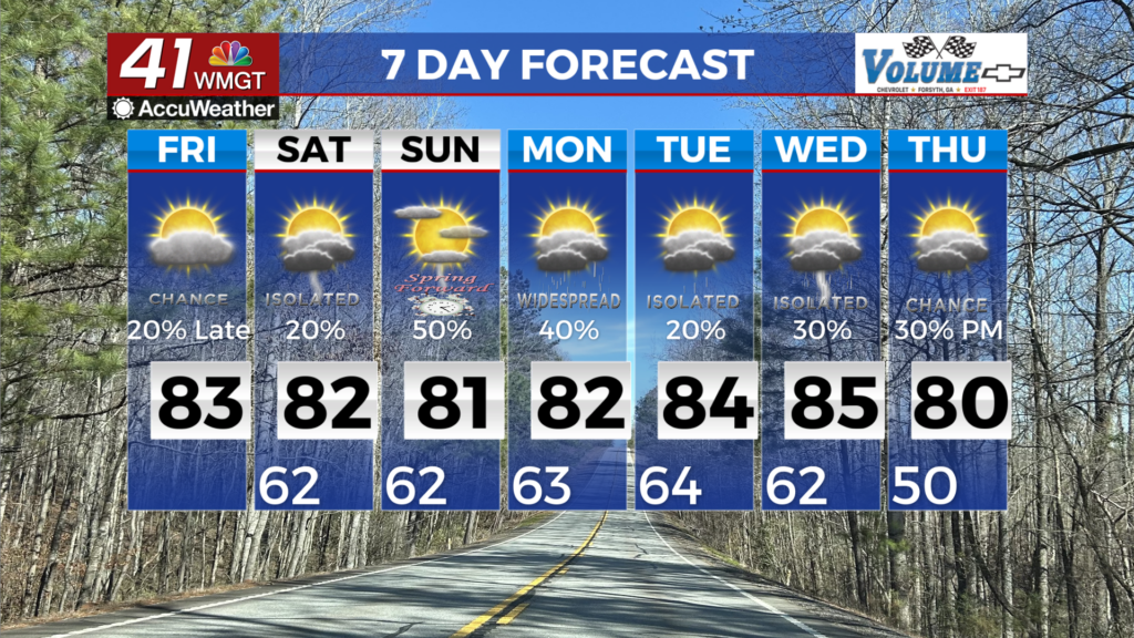
Rain and storms return Thursday afternoon, some could be severe
A line of showers and storms will move into Middle Georgia Thursday that will bring heavy rain, gusty winds, and even some hail.

Despite the early cloud cover, most of Middle Georgia saw a nice weather day Wednesday.
This evening we are tracking a line of storms moving in from Alabama that could impact our area overnight.
Clouds will stick around into Thursday morning, with highs warming back into the 80s.
A few isolated storms will be possible in the morning, but the main line of storms will push through after 2 pm.

Rain and storms will push out of the area Thursday evening, with a few showers possible overnight.

With regards to strong storms, the Storm Prediction Center has our area under a level 1 threat outlook.
The main impacts from any storms Thursday will be damaging winds and hail.
Tornadoes are not likely, but we can’t rule out a spin-up.

Friday will be hit-and-miss with storms, but the main area to watch for storm activity will be along the cold front.
Severe storms won’t be as widespread Friday, but a few storms could be strong.

Once again, the main impacts from severe storms will be damaging wind gusts, hail, and a spin-up tornado can’t be ruled out.
The window for severe storms will be pretty narrow for our area, with storms moving out during the evening.
We will get a break from storms Friday night through Saturday during the day.
Highs will also be staying in the 80s through Saturday.

Sunday will bring another chance of showers and storms as low pressure moves in from the Gulf of Mexico.
This will bring heavy rain and yet another chance for strong and severe storms.
Timing on this one is a little more up in the air, so stick with 41NBC for future forecasts.

As mentioned above, heavy rain will be possible between now and Sunday evening.
Some areas could see up to 3″ of rain through the weekend.

Weather will be a bit cooler next week as clear skies return to the area.
It will be a slow warm-up into the 70s by the middle of next week.