Picture perfect weather for later this week; rain for weekend
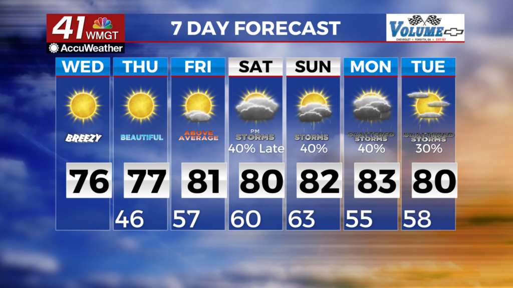
MACON, Georgia(41NBC/WMGT) – Strong northwest winds drawing in dry air at the surface combines with strong afternoon mixing of daytime heating will contribute to  low relative humidity for our area. This will push us into fire danger. Depending on how strong the winds get will determine if we are issued Red Flag warnings. Highs today will be in the 70s across the region. Lows should fall into the 40s. The extended forecast continues with a dominate high pressure ridge over the Southeast, resulting in dry and sunny conditions. Despite a shift in the center of the ridge, Thursday will continue to have low surface dewpoints that will persist the fire danger concerns. By Friday, southerly flow is expected to provide some relief as incoming moisture keep relative humidity from dropping into the critical fire danger zone. Under high pressure, temps will bake to above seasonal levels, with Thursday highs 2-7 degrees above normal, and Friday 7 to 13 degrees above normal. For the weekend, we are watching an upper level trough and associated low in the Central Plains to move east. Southerly flow will usher in Gulf moisture into the southeast, increasing instability over the area and priming the region for potential storm activity late weekend and early next week. Precipitation chances return by Saturday afternoon, and a good chance it will remain in the forecast into Monday.