
Near-record highs possible Thursday and Friday
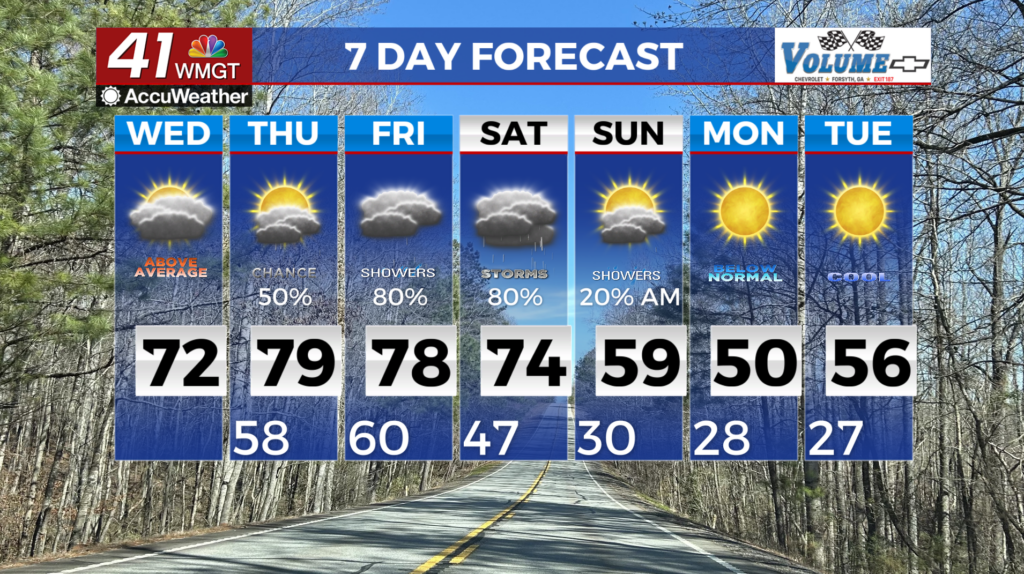
MACON, Georgia (41NBC/WMGT) – Winds have shifted south and warm air has surged into Middle Georgia. Expect dewpoints to surge along with daytime high temperatures. Cloudy conditions 


due to moisture advection with overcast skies for all but the far southeast counties. Patchy to dense fog may be possible through this morning for areas south of Atlanta and west of Macon. Current satellite views are showing clearing for the southern and southeastern counties, which would allow for cooling for fog development. Periods of light drizzle and rain showers are possible through the day today. Any precipitation will be exceptionally isolated and measure a trace at best. The next opportunity for precipitation comes during the day Thursday as warm air advection and moisture advection continue and a stalling front approach. Some light accumulation of rain will be possible with this shot and models have indicated the presence of more consistent precipitation. Friday will be the last day of well above normal temperatures before a front begins pushing into the area for the weekend. Friday morning temperatures will only get down to the low to mid 60s across a majority of the area. This along with high temperatures topping out in the mid to upper 70s — low 80s for far southeastern central Georgia will likely lead to records being tied or broken. We will see the front sink southward into the area on Friday with the first wave of rainfall beginning to push into the afternoon. Models continue to show the front stalling over the area somewhere between Atlanta and Macon through Saturday afternoon. Models do digress a bit on how quickly a northeastern system pushes this front out of out area with some showing it’s out of the area by overnight Saturday and some lingering into Sunday morning. The current forecast showcases slower movement but overall by late Sunday morning should see most of the rain chances out of much of Georgia. Early next week temperatures will drop to 15 to 20 degrees below normal after the cold front passes through with high temps in the 40s possible. Winter is not over just yet.