More rain with more normal temperatures
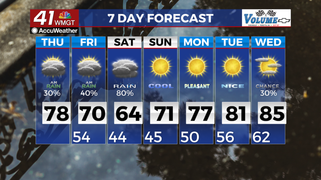
MACON, Georgia (41NBC/WMGT) – Broken low clouds in the morning after daybreak will begin to scatter out in the late morning and early afternoon. Highs will be cooler than yesterday, in the 


low to mid 70s along I-85 and in the upper 70s to near 80 to the south. After trailing showers behind the convective system come to an end across the region, a slight chance for showers may persist in the far southern portion of the state near the stalled boundary. The unsettled weather is expected to continue as the upper level trough finally pushes out Saturday afternoon into the evening. Most of the activity will be rain, although instability could build across portions of the southern part of the area through mid afternoon to result in some thunderstorms south of Columbus to Macon. While widespread severe weather is not expected, a few strong storms could be possible. High pressure establishes on Sunday and kicks off another dry period with building heat. Modest temperatures on Sunday in the upper 60s and low 70s will quickly rebound on Monday as they climb back into the upper 70s and 80s for the remainder of the week. This will be accompanied by drier conditions, with relative humidity falling into the 30 percent range during the afternoon. Overnight lows Sunday into Monday will be in the low 40s with some upper 30s possible across the higher elevations. Lows rebound with highs by the end of the week into the mid to upper 50s.