
Models Show Increasing Confidence for Snowfall in Middle Georgia Overnight
MACON, Georgia (41NBC/WMGT) – The 41First Alert Storm Team has been monitoring the approaching cold front very closely, as it has the potential to produce light snow showers across Middle Georgia overnight.
Tuesday morning, the forecasting models were more on board for the chance of snow, showing cold air overlapping lingering moisture. However, there are still a few inconsistencies regarding the models.
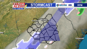
The RPM today shows a different trend than yesterday – this model shows dry air cutting off precipitation northeast of Perry. It’s also showing the potential for any snow to fall in Middle Georgia later in the morning, around 6 a.m.
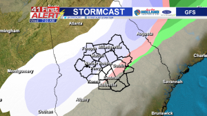
Meanwhile, the GFS – which was showing a dry front Monday – showed a much wetter trend. This model shows snow showers pushing into Monroe County around 1 a.m and clearing out of Telfair County by noon.
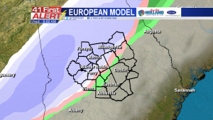
Lastly, the European model continues to show moisture from the front mixing with the cold air, resulting in snow showers across Middle Georgia. This model’s timing for snow is the same as the GFS.
Compiling the data collected from these models, Middle Georgia could see spotty, light snow showers or a more widespread swath of light snowfall.
While it’s exciting to see snow in the forecast, we’re not expecting high accumulations. Latest forecast data points at about half an inch to an inch and a half possible.


Leave a Reply