
Winter weather advisories and warnings issued for multiple Middle Georgia counties
Snow, extreme cold expected Saturday through Sunday across the 41NBC coverage area
MACON, Georgia (41NBC/WMGT)- A series of winter weather advisories, winter storm warnings, and an extreme cold warning have been issued for counties across the 41NBC coverage area, with impacts expected from early Saturday through Sunday afternoon.
Winter weather advisory
A Winter Weather Advisory is in effect from 1 a.m. to 7 p.m. Saturday for Monroe, Crawford, Bibb, Peach, Houston, Bleckley, Pulaski, Dodge, Telfair, and Wheeler counties.
Forecasters expect snow accumulations of up to one inch, with wind gusts as high as 35 mph. Officials said any snow is expected to rapidly stick to roads and other surfaces due to temperatures in the 20s. Gusty winds could lead to blowing snow and reduced visibility, creating difficult travel conditions.
Wind chills are expected to range from 5 to 15 degrees above zero Saturday, dropping to the single digits below zero to single digits above zero Saturday night.
Residents are advised to consider delaying travel. Those who must travel are urged to keep emergency supplies in their vehicles, including food, water, and a flashlight.
Extreme cold warning
An Extreme Cold Warning is in effect from 7 p.m. Saturday to 1 p.m. Sunday for Hancock, Monroe, Jones, Baldwin, Washington, Taylor, Crawford, Bibb, Twiggs, Wilkinson, Johnson, Macon, Peach, Houston, Bleckley, Laurens, Treutlen, Dooly, Pulaski, Wilcox, Dodge, Telfair, and Wheeler counties.
Officials said dangerously cold wind chills are expected, ranging from as cold as 15 degrees below zero in north Georgia to the single digits above zero in central Georgia.
The warning notes that frostbite and hypothermia can occur if skin is exposed to these temperatures. Prolonged freezing conditions could also cause water pipes to rupture.
Residents are urged to dress in layers if going outside, take steps to prevent pipes from freezing, keep pets indoors, and check on elderly neighbors and relatives.
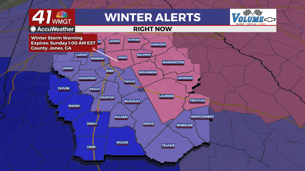
Winter storm warnings
Several Winter Storm Warnings are in effect from 1 a.m. Saturday to 1 a.m. Sunday for parts of the coverage area.
Hancock and Baldwin counties: Heavy snow is expected, with 3 to 5 inches of accumulation possible and locally higher amounts. Wind gusts could reach 35 mph.
Jones and Wilkinson counties: Snow accumulations of up to 2 inches are expected, with higher amounts possible in some locations.
Laurens and Treutlen counties: Snow accumulations of up to 2 inches are forecast.
Johnson County: Snow accumulations between 1 and 3 inches are expected.
Officials said roads, especially bridges and overpasses, are likely to become slick and hazardous in warning areas. Blowing snow and reduced visibility could make travel very difficult to impossible at times.
Wind chills across warning areas are expected to range from the single digits below zero to the teens above zero, depending on location and timing.
Residents across all affected counties are urged to stay indoors if possible until conditions improve and to use caution if travel cannot be avoided.