Cold Week Ahead with a Chance for Snow in Middle Georgia Tuesday Night
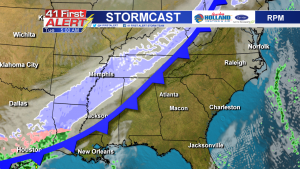
MACON, Georgia (41NBC/WMGT) – Another front is sweeping across the country this week, bringing a blast of cold air that’s overlapping moisture and creating snow showers. Monday morning, snow was visible on radar from Kansas to eastern Kentucky and Ohio.

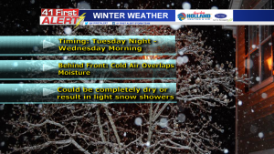
The cold front will be moving into the southeast on Tuesday. The potential for snow exists mainly Tuesday night into early Wednesday morning for Middle Georgia.
Before you get your hopes up, it’s important to note that the models are inconsistent regarding how much snow will fall (if any) and when it will fall.
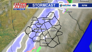
The RPM shows scattered snow showers across Middle Georgia starting as early as 8 Tuesday night and ending around 7 Wednesday morning.
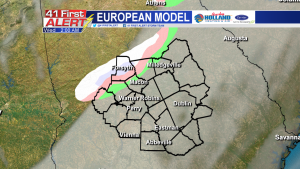
The European model shows the precipitation holding together behind the front, but the timing is different. This model predicts the snow showers occurring in Middle Georgia around midnight Wednesday through 7 a.m.
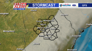
The GFS model, however, shows a lack of precipitation as the front moves through Middle Georgia. If this model is correct, the air will be too dry to result in any snowfall.
North Georgia has the best chance for seeing accumulating snowfall, with predicted totals up to one inch. In Middle Georgia, we could either see nothing if the air dries out, or we could get a light dusting of snowfall.
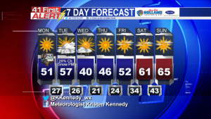
One thing is for certain: behind the front it will be very cold! Temperatures will drop from the upper 50’s Tuesday afternoon to barely breaking the 40’s Wednesday afternoon.
This forecast is likely to change. Stay with 41NBC for the latest updates and download our 41First Alert Storm Team app for your mobile devices.


Leave a Reply