


Isolated showers return today
MACON, Georgia. (41NBC/WMGT) – We will be sandwiched between two weather systems today that will aid in the development of isolated to scattered showers this afternoon.
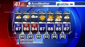
TODAY.
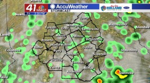
A low pressure center off the eastern coast of the Florida peninsula and an area of low pressure out to our west will send moisture our way and that will allow showers and a few thunderstorms to form this afternoon. Under a partly to mostly cloudy sky temperatures will be back in the middle and upper 80’s before falling into the lower and middle 60’s overnight tonight under a party to mostly cloudy sky.
TOMORROW.
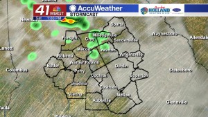
Better chances for rain return tomorrow afternoon and evening ahead of a cold front that will clear the area later on Sunday. The day will not be a washout tomorrow, but the chance for scattered showers and thunderstorms do exist as we get into the thick of the afternoon heat. High temperatures tomorrow will be topping out in the middle 80’s due to the added cloud cover while overnight low temperatures will be back in the middle 60’s under a mostly cloudy sky.
SUNDAY & BEYOND.
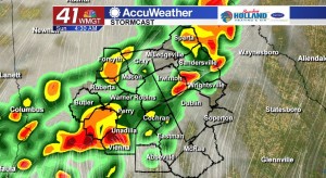
During the morning hours on Sunday we will see a cold front pass through the region that will bring the chance for rain, gusty winds, hail, and frequent lightning to Middle Georgia. Showers will hang around through the afternoon hours, but by the evening we will be clearing out and drying out as we head into the next work week. We will start the week off dry before slight rain chances return to our area by the middle of the week.
 Follow Meteorologist Dalton Mullinax on Facebook (Dalton Mullinax 41NBC) and Twitter (@MullinaxWX) for weather updates throughout the day. You can also watch his forecasts Monday through Friday on 41NBC News at Daybreak (5-7 a.m.) and 41Today (11 a.m.).

Leave a Reply