Follow Meteorologist Dalton Mullinax on Facebook (Dalton Mullinax 41NBC) and Twitter (@MullinaxWX) for weather updates throughout the day. You can also watch his forecasts Monday through Friday on 41NBC News at Daybreak (5-7 a.m.) and 41Today (11 a.m.).
Isolated showers hang around through the weekend
MACON, Georgia. (41NBC/WMGT) – A cold front will stall out across Middle Georgia this afternoon setting up for a wet weekend in Middle Georgia.
TODAY.
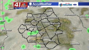
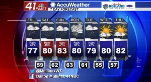
The cold front that has been moving in from the west has finally made it to the Peach State and it is going to eventually stall out across Middle Georgia as we head into the weekend. This afternoon we will be dealing with a mostly cloudy sky and isolated showers. While the heaviest of the rain has moved out of our region, we will be dodging showers all afternoon and evening. Temperatures today will be topping out in middle 70’s while overnight low temperatures will be falling into the upper 50’s and lower 60’s.
WEEKEND.
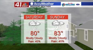
Your weekend weather looks to be the same on both Saturday and Sunday. Under a partly to mostly cloudy sky we will be dealing with isolated showers all weekend long. The stalled out cold front in our region will act as a jump-start for showers during the weekend. Temperatures will top out in the low 80’s on both Saturday and Sunday while overnight low temperatures will be in the lower 60’s.
NEXT WEEK.
Widespread showers and thunderstorms return to Middle Georgia on Monday as a cold front sweeps through in the afternoon. On Tuesday we will see a few lingering showers, but by the middle of the work week we begin to clear out and bring back in a lot of sunshine!


Leave a Reply