
Incoming front rises rain chances heading into the weekend
MACON, Georgia (41NBC/WMGT) – After a mostly dry week across Middle Georgia, rain chances will rise heading into the weekend as a stalled front starts moving again.
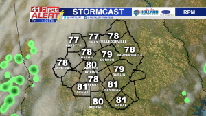
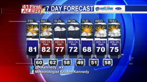
Friday, however, will still be warm and dry. Temperatures in the afternoon will likely climb into the upper 70’s and low 80’s in Middle Georgia. The day will start with some sunshine, and clouds will form in the afternoon. Sky conditions will be partly cloudy at worst. Rain chances will be minimal as isolated showers should stay in west Georgia.
The forecast for Saturday will be very similar to Friday, though a slight chance of rain will be introduced in the late afternoon through evening hours.
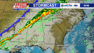
Sunday, the frontal system that has been stationary across the western-southeast states will start to shift east. As it does so, rain chances will increase. Scattered showers and some thunderstorms are possible across Middle Georgia.
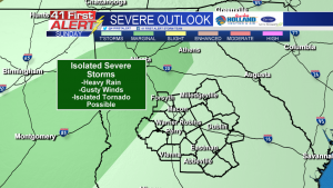
Friday morning, the Storm Prediction Center placed a small section of Middle Georgia under a marginal risk for severe weather. Northwest Monroe, Crawford and Taylor county may be affected by a storm that could turn severe.
The storm threats heading into Sunday will mainly be heavy rain (totals could range from 0.25-1.00 inch) and gusty winds, but an isolated tornado cannot be completely ruled out of the forecast.
Along with the rain, comes a blast of cooler air. High temperatures will drop from the 80’s on Saturday into the low 70’s by Monday and dip into the 60’s Tuesday. Tuesday also looks to be one of the sunnier days of the week, before clouds build back in mid-week.
 Connect with Meteorologist Kristen Kennedy on Facebook and Twitter for weather updates throughout the day. You can also watch her forecasts Monday through Friday on 41NBC News at Daybreak (5-7 a.m.) and 41Today (11 a.m.).


Leave a Reply