

Hit or miss showers for Middle Georgia over next few days
MACON, Georgia. (41NBC/WMGT) – We have another day of light isolated showers in store across Middle Georgia.
TODAY.
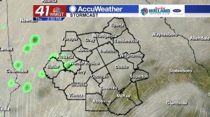
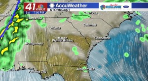
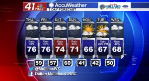
Yesterday afternoon we dealt with a mist and drizzle for the better part of the afternoon, and the cooler temperatures ushered in by a “wedge” pattern kept us in the low 50’s. By this afternoon, temperatures will slowly but surely be on the rise into the low and mid 70’s across our area. Once again today the heaviest of the rain will stay well to our north and west, but isolated showers and a few rumbles of thunder across Middle Georgia will be in our area. Overnight tonight under an overcast sky temperatures will be on the very warm side. Overnight temperatures will be running in the mid and upper 50’s. With a calm wind expected, patchy dense fog is likely tomorrow morning.
TOMORROW.
Tomorrow we are going to be waking up to a mostly cloudy sky and warm temperatures. By the time that we get to the afternoon, temperatures will be back in the middle 70’s. An area of high pressure will move into the New England region late on Friday, and this will give us a northeast wind into Middle Georgia as we head into the overnight hours. This setup allows for a lot of clouds accompanied by mist and drizzle.
WEEKEND.
While we will be dealing with rain on both days of the weekend, neither day is going to be a complete washout. On Saturday temperatures will be in the low 70’s and we will be seeing isolated showers all day long. Sunday morning a cold front moves through bringing with it widespread rain. Behind this front we will be drying out as we head into the work week!
 Meteorologist Dalton Mullinax on Facebook (Dalton Mullinax 41NBC) and Twitter (@MullinaxWX) for weather updates throughout the day. You can also watch his forecasts Monday through Friday on 41NBC News at Daybreak (5-7 a.m.) and 41Today (11 a.m.).


Leave a Reply