Flood warnings and watches in effect for Middle Georgia
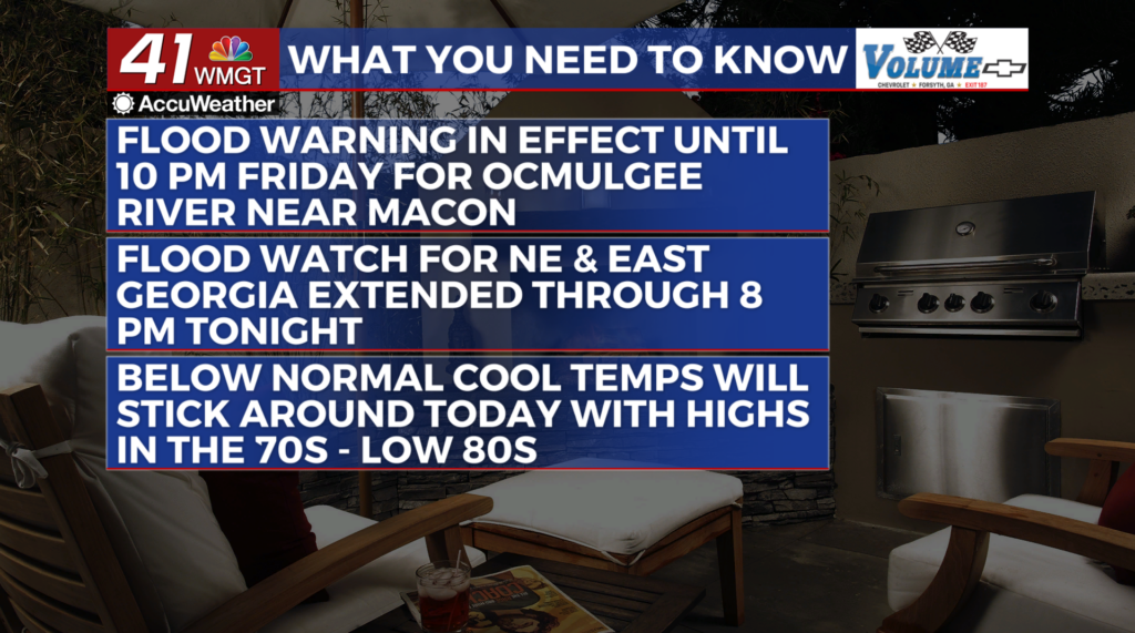
MACON, Georgia (41NBC/WMGT) – A Flood Warning has been issued for Bibb County until Friday evening and the Flood Watch has been expanded to include all of northeast and east Georgia for 


 Tuesday evening. A blanket of clouds and waves of light to moderate rain showers has made for a dreary Monday across the state of Georgia. This activity has kept temperatures in the 60s to low 70s so far today. Temperatures are not expected to deviate too much from what they are now give or take 2-4 degrees. These temperatures are quite a change from what we experience last week and a few locations may actually break the record for the lowest maximum high temperature for today. A very moist airmass remains place across the Southeast. Strong easterly flow along the lee side of the Appalachians has kept the wedge firmly in place across North and Middle Georgia. Over the next 24 to 36 hours, continued rounds of rain showers and isolated thunderstorms are anticipated, particularly within the current watch area. Radar imagery is showing heavier rain showers slowing moving over these areas. Clouds and periods of rainfall will continue to keep temperatures well below normal. Forecast high temperatures on Tuesday will be similar to today. Overnight lows are forecast to be in the 60s to low 70s Tuesday night.