Fire weather possible as temps continue to warm
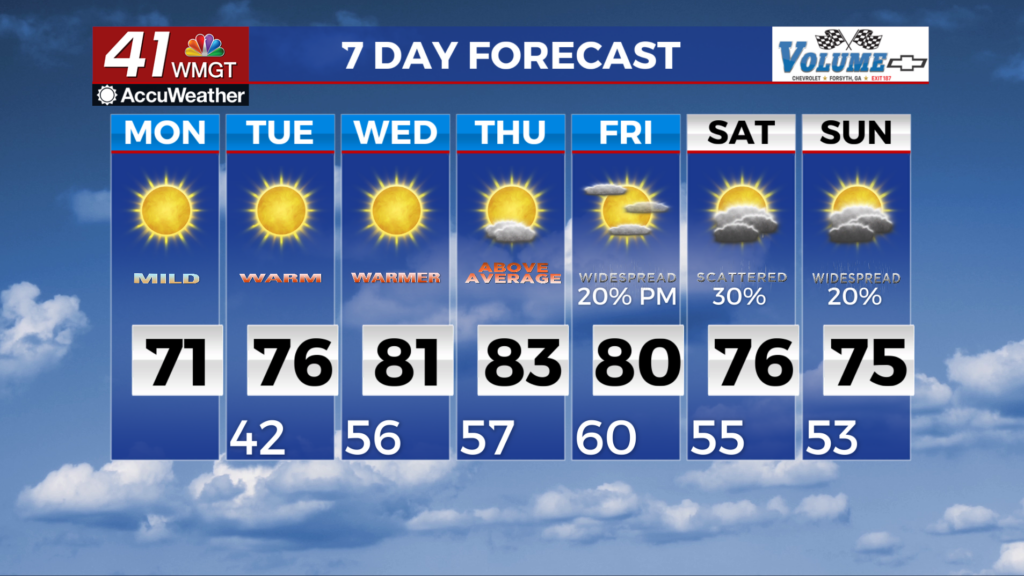
MACON, Georgia (41NBC/WMGT) – Dry conditions and much warmer than normal temperatures will continue across north and Middle Georgia during the middle of the upcoming week. This 


 pattern is being driven by a mid-level ridge that will build across the Southeast U.S. from over the Gulf through the end of the week. A few shortwaves and associated moisture will ride along the top of the ridge and could at most only bring a few showers to far North Georgia on Wednesday into Thursday. On Friday, a shortwave and associated surface low will rapidly eject out of the Southwest U.S. up into the Midwest. This will push the ridge a little further east and turn winds aloft out of the southwest, bringing in sufficient moisture across the western half of the state to support scattered showers or storms. The overall pattern look like it will remain fairly stagnant through the rest of the weekend, with troughing over the Southern Plains and Southwest U.S., and ridging over the Southeast coast. This supports warm temperatures and isolated to scattered showers and storms each day, primarily across west and northwest Georgia. High temperatures from midweek into the weekend will be 12 to 18 degrees above normal, ranging from the mid 70s to low 80s across the area. We could see a few daily record highs either tied or broken. Overnight lows will be 14 to 20 degrees above normal, ranging from the mid 50s to low 60s.