


Dry week ahead in Middle Georgia as Dorian moves closer to U.S. mainland
MACON, Georgia. (41NBC/WMGT) – Mostly dry and sunny conditions are expected across Middle Georgia this week as all eyes are on Hurricane Dorian.
TODAY.

This afternoon under a partly to mostly sunny sky we will see temperatures climbing into the upper 80’s and lower 90’s across the area. While I do expect for most of our areas to stay dry, there could be a few showers drift into our southeastern counties. Overnight temperatures will cool off into the upper 60’s and lower 70’s under a mostly clear sky.
DORIAN.

As of the 5 am update from the National Hurricane Center, Hurricane Dorian is still a Category 5 storm as it batters Grand Bahama Island. Dorian is nearly stationary this morning as its westward movement is only one mile per hour. While the latest forecast track does not currently have Dorian making landfall on the Florida coast, hurricane force winds, extreme storm surge, and heavy rain will still batter the Florida coastline. Later this week, Hurricane Dorian is expected to move off to the northeast where landfall on the Outer Banks is possible. This forecast is not set in stone and will be adjusted over the next few days.
 TOMORROW.
More sunshine is on the way for your Tuesday afternoon as temperatures are going to return to the lower 90’s with slim rain chances. Overnight temperatures will bottom out in the lower 70’s.
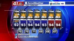
EXTENDED FORECAST.
It is going to be a dry seven day forecast for the most part with above average temperatures. The average high temperature this time of year is in the upper 80’s, but over the next several days we will be in the lower to middle 90’s.
 Follow Meteorologist Dalton Mullinax on Facebook (Dalton Mullinax 41NBC) and Twitter (@MullinaxWX) for weather updates throughout the day. You can also watch his forecasts Monday through Friday on 41NBC News at Daybreak (5-7 a.m.) and 41Today (11 a.m.).

Leave a Reply