

Dry & warm start to the week; rain mid-week
MACON, Georgia (41NBC/WMGT) – A wedge front is forecast to move in east of the Appalachians overnight bringing cloudy skies and cooler temperatures particularly to Northeast Georgia on 


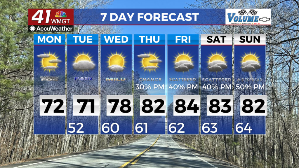
Monday. The latest models highlight a potential for isolated showers across North Georgia on Monday. The big question will be the magnitude and the extent of the wedge. Forecast high temperatures will range from mid 50s within the wedge to upper 70s outside the wedge. Monday night temperatures will range from the 40s within the wedge to mid 50s. The wedge of cool air starts to erode on Tuesday as the strong high pressure shifts east over the western Atlantic and the breezy easterly winds start to slacken. High temperatures will begin to have a large spread over the area, with upper 60s to mid 70s outside it. A mid-level ridge starts to slide over the area on Wednesday, and start to bring in a warmer airmass within south-southwest flow. High temperatures will likely be in the 70s across the area, with 80s possible across Middle Georgia. For the second half of the week, the weather pattern over the U.S. shifts, as a strong mid-level ridge builds over the East Coast, and troughing sets up over the Central and Western U.S. This pattern results in deep southwest flow over Georgia, which will bring in an increasing warm and humid airmass from Thursday through next weekend. High temperatures will likely be in the upper 70s to mid 80s each day, with lows in the upper 50s to mid 60s. The warmest days are looking like Friday and Saturday, with temps reaching the 80s across the area with records being tied or broken depending on cloud cover. Models are in agreement on rain chances starting to pick up on Thursday and Friday, before ramping up even more over the weekend.