


Dry end to winter
MACON, Georgia. (41NBC/WMGT) – Behind yesterday’s cold front passage we are feeling drier and cooler air in Middle Georgia.
TODAY.
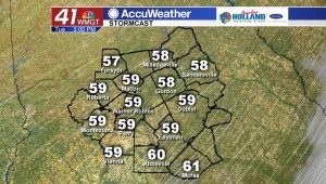
The cold front that moved through yesterday evening continues to move further to the south, and behind that weak front we will see a blue sky this afternoon combined with cooler than normal temperatures. The average high temperature for this time of year is 70° and we will stay below that threshold this afternoon as I am expecting afternoon high temperatures to hover in the low to middle 60’s across the region. With a clear sky, expect temperatures to fall quickly after sunset tonight on this final full day of winter. Sunset is set for 7:45 this evening and temperatures will fall back into the mid and upper 30’s overnight tonight.
TOMORROW.
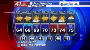
Spring begins tomorrow with the vernal equinox at 5:58 pm! The warming trend begins tomorrow as well as we begin to tack on a few degrees to the daily high temperature over the next several days. I am once again expecting a dry and sunny day tomorrow with just a few high clouds. Temperatures will be running in the mid to upper 60’s before falling into the upper 30’s and lower 40’s overnight under a mostly clear sky.
REST OF WEEK & BEYOND.
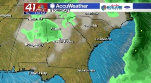
Another weak cold front will move through during the day on Thursday, but once again this system will be limited in the rain department. While rain chances are slim, they are not zero. I am keeping rain chances at less than 10% on Thursday with this clipper type system that will move through. By the time we get to the weekend I am expecting a lot of sunshine combined with temperatures warming into the middle 70’s.
 Follow Meteorologist Dalton Mullinax on Facebook (Dalton Mullinax 41NBC) and Twitter (@MullinaxWX) for weather updates throughout the day. You can also watch his forecasts Monday through Friday on 41NBC News at Daybreak (5-7 a.m.) and 41Today (11 a.m.).

Leave a Reply