Dry conditions increase fire danger
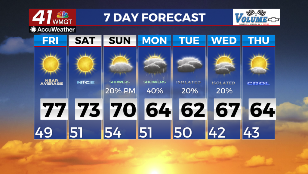
MACON, Georgia (41NBC/WMGT) – High pressure has settled over the Southeast and will promote another day of crisp and dry conditions across North and Middle Georgia. Light winds 


and clear skies overnight enhances radiational cooling, with low temperatures in the 40s across most of the area. Considering the building high pressure and mostly clear skies over the course of the day, temperatures this afternoon were a few degrees warmer than yesterday, with highs primarily in the mid 70s in North Georgia and upper 70s in Middle Georgia. Strong subsidence under the high will also contribute to the mixing down of dry air aloft during daytime heating. With the relative humidity at or below 25%, a Fire Danger Statement has been issued for locations with low relative humidity and dry fuels, and remains in effect until 8 PM this evening. Upper level troughing over the eastern U.S. shifts towards the Atlantic coast overnight. As this occurs, a weak shortwave rotating around the southwestern side of the trough will push a moisture-starved cold front through North Georgia. Dewpoints will briefly increase into the upper 30s and low 40s ahead of the front, but no precipitation or severe weather is expected as it passes. A reinforcing shot of cool, dry air will enter North Georgia in the wake of the front and ahead of another surface high approaching from the northwest. After another night of efficient radiational cooling, lows on Friday morning will be in the upper 30s to low 40s to the north of I-20 and mid to upper 40s to the south. Highs on Friday will be in the mid 60s to low 70s in North Georgia within the cooler air behind the front, and mid to upper 70s in Central Georgia.