Dry conditions continue into the weekend
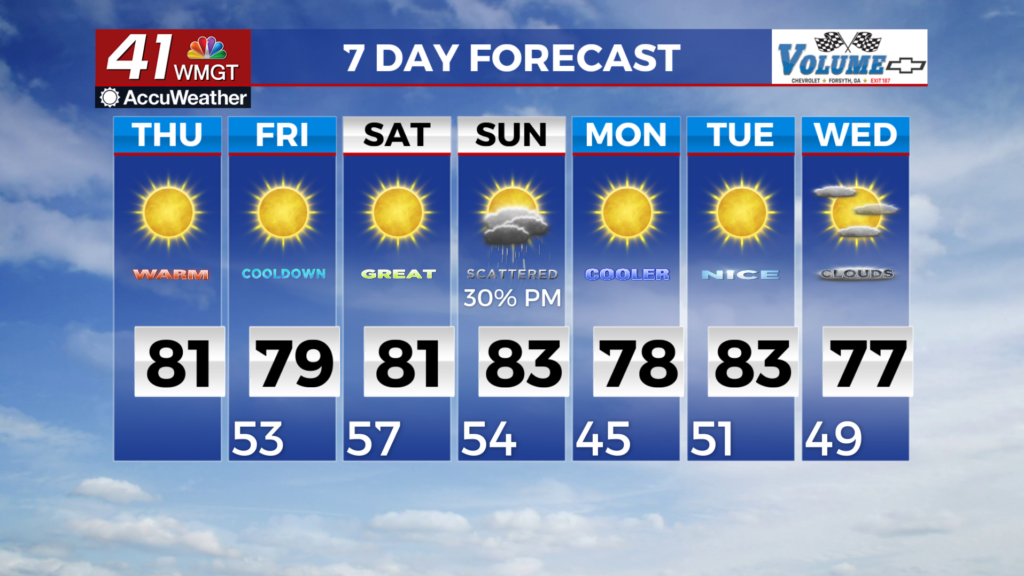
MACON, Georgia (41NBC/WMGT) -We will start the day with mostly clear skies with high pressure and a dry airmass across the region. The models are showing a dry back door cold front 


 moving southwest out of the Mid-Atlantic region sweeping through Georgia today. Expect some increased high clouds from this however, it will allow the high pressure ridge over the eastern Great Lakes to build down into the Mid-Atlantic and eventually into the Southeast by Friday morning. This ridge will bring in some slightly cooler daytime high temps Friday but that’s about it for the short term. Temperatures are expected to stay in the 70s and 80s with lows in the 50s and 60s. Dry conditions will remain the main story through the start of the weekend as a mid-level ridge slides across the Southeast U.S. and troughing drops across the middle of the country behind it. The ridge will prevent any chances for rain across the state. High temperatures for Friday into Saturday will be in the upper 70s to low 80s, with overnight lows in the mid to upper 50s. By late Saturday, the pattern begins to shift as the ridge gets kicked out of the area by deep troughing pushing east from the Central U.S. As a result, low to mid-level winds over Georgia will start to turn out of the south to southwest, strengthening by Sunday morning as a shortwave drops into the Mississippi and Tennessee Valleys. The surge of southwest flow brings increased moisture, combined with the nearby trough will lead to scattered showers and thunderstorms across the area starting Sunday morning. By Sunday afternoon, the cold front associated with this system starts to push through Georgia from the west/northwest, with showers and storms around until it passes through and drier air filters in. Any rainfall from this system, will not make much of a dent in the ongoing drought conditions. Behind the front, surface high pressure and ridging moves over the region, ushering in dry cooler conditions for Sunday night through early Tuesday. Low temps during this period may be the coolest we’ve seen so far this season, falling into the upper 40s to low 50s for Monday and Tuesday mornings. Hello Autumn!