Dry conditions continue & finish out the week
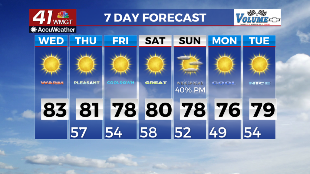
MACON, Georgia (41NBC/WMGT) – Dry conditions remain the story through the start of the weekend as a mid-level ridge slowly slides across the Southeast U.S. as troughing drops across the 


 Central U.S. in its wake. The ridge will prevent any chances for rain across Georgia, and leads to mostly clear skies. Expansive high pressure riding along the northeast side of the ridge will send a dry front into the state from the Carolinas on Thursday, which will cool temps a few degrees for Friday, but will otherwise be unnoticeable. High temperatures for Thursday through Saturday will be in the upper 70s to low 80s, with overnight lows in the 50s. By late Saturday, the pattern will begin to shift as the ridge gets kicked out of the area by broad and deep troughing pushing east from the Central U.S. In response, low level winds over Georgia will start to turn out of the south to southwest, strengthening by Sunday morning as a shortwave drops into the Mississippi and Tennessee Valleys. The surge of southwest flow will bring increased moisture, combined with the nearby trough will lead to scattered showers and thunderstorms across the area starting Sunday morning. By Sunday afternoon, the cold front associated with this system will start to push through Georgia from the west/northwest, with showers and storms around until it passes through and drier air filters in behind it. There is still uncertainty with how this system will progress, but depending on the timing of the front and how much instability develops in the area, a few strong to even marginally severe storms may be possible. That part of the forecast will become clearer in the coming days. Any rainfall from this system, will not make much of a dent in the ongoing drought conditions. Behind the front, surface high pressure and mid-level ridging moves over the region, ushering in dry and cooler conditions for early next week. Low temperatures may be the coolest we’ve seen so far this season, falling into the upper 40s to low 50s for Monday and Tuesday mornings. Highs look to be in the low to mid 70s on Monday, and the mid to upper 70s on Tuesday.