
Dry cold front brings cooler temps to Middle Georgia
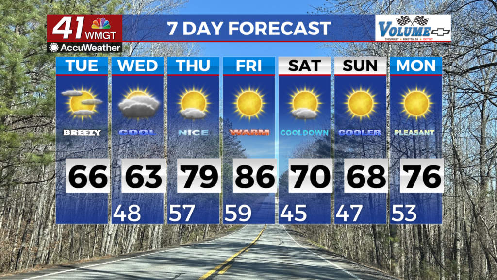
MACON, Georgia (41NBC/WMGT) – Current conditions show some clouds streaming across the area associated with a dry frontal boundary. Currently the front is just south of Atlanta and 


continues to push south. This boundary is expected to stall along the Georgia/Florida border and remain stationary through Wednesday morning. Dry northwest winds are increasing behind the front with dewpoints in the upper 40s to lower 50s. This drier airmass moving into the area continues however, it will be short lived. With the front stalled near the southern Georgia border a wave begins to develop across south Georgia with precipitation chances slightly increasing Tuesday night across central portions of the state. Very little instability associated with this wave so do not expect any severe weather but maybe we will see some isolated showers and thunderstorms Wednesday morning. Temperatures will be a bit cooler today with highs in the mid 60s to low 70s. This northerly flow behind the front will bring in some cooler temperatures — about 10 to 15 degrees lower than yesterday with highs in the upper 50s to near 70. At the start of the forecast period, high pressure will be centered just off the east Carolina Coast with upper level ridging covering roughly the western two-thirds of the U.S. The combination of a passing wave and a weak cold air wedge in place across north Georgia will result in persistent cloud cover, lingering morning rain chances, and more seasonal temperatures on Wednesday. High temperatures will be in the 60s areawide with 50s in the mountains. Through the remainder of the workweek upper level ridging continues to broaden and inch east while high pressure stays at the surface. Another weak frontal boundary is expected to sag south from the Tennessee Valley on Friday, although upper level support quickly shifts northeast, so any rain chances remain to the far North Georgia area.