
Drier end to the work week before rain returns this weekend
MACON, Georgia (41NBC/WMGT) – While some southeastern states can not avoid the rain a stationary front is producing, Georgia will be staying mostly dry heading into the weekend.
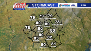
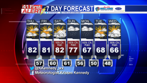
The Bermuda High over the Atlantic will help to clear out some cloud cover on Thursday. Sky conditions will be partly cloudy in the afternoon. More sunshine will help temperatures climb back into the low 80’s. This will also be the trend Friday.
Saturday, the stalled front will produce widespread, scattered showers across the southeast. Isolated showers will be possible in Middle Georgia.
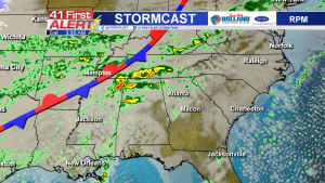
The frontal system will start to shift towards the state of Georgia on Sunday. As it moves closer, rain chances will increase. Middle Georgia’s best chance of rain will come on Sunday and Monday in the form of scattered showers with some storms possible.
A surge of colder air will arrive early next week behind the front. Temperatures are expected to drop from the 80’s on Saturday to the 60’s by Monday.
 Connect with Meteorologist Kristen Kennedy on Facebook and Twitter for weather updates throughout the day. You can also watch her forecasts Monday through Friday on 41NBC News at Daybreak (5-7 a.m.) and 41Today (11 a.m.).


Leave a Reply