Dangerous heat on tap for the weekend
MACON, Georgia (41NBC/WMGT) – Hot and humid weather will be the order of the day in Georgia again today, with the region stuck between a trough in the Gulf and a ridge along the 


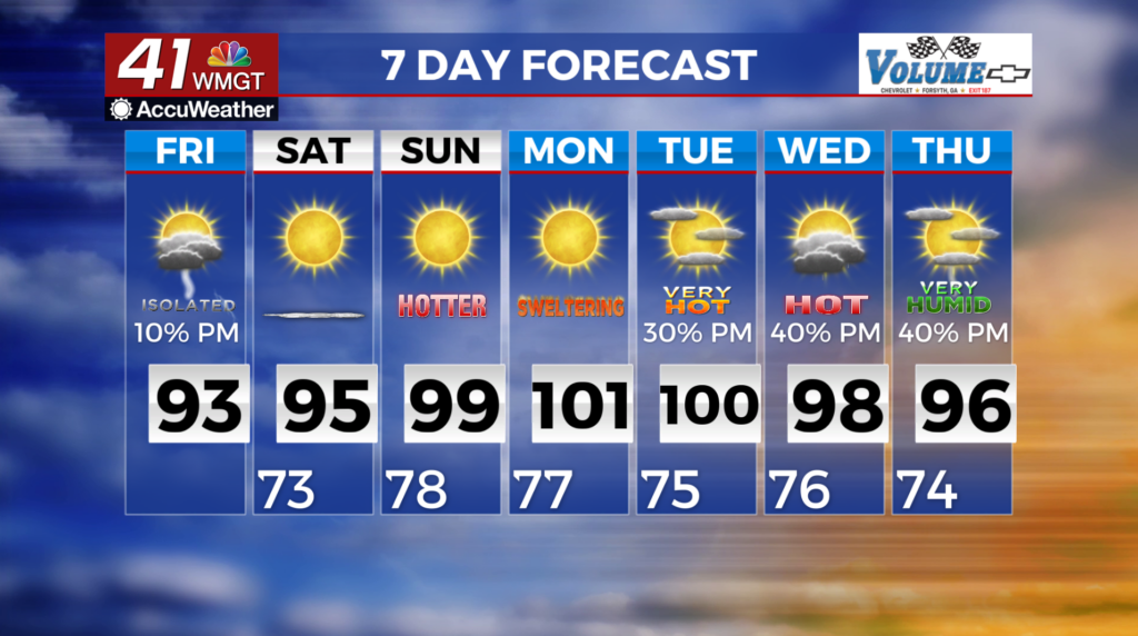
 Carolina coast. Widespread high temperatures in the lower 90s are expected, with heat indices peaking in the 97 to 102 degree range. Daytime heating will lead to isolated thunderstorm activity this afternoon. The highest storm chances are expected in West Central Georgia due to weaker subsidence and weak convergence along with afternoon sea breeze. Any storm may produce frequent lightning, brief bursts of heavy rain or locally breezy downburst winds. Any lingering storm activity should dissipate rapidly after sunset due to the loss of diurnal heating. This will leave the region with quiet weather and lows in the 70s tonight. Patchy fog could occur but widespread fog is unlikely. Upper level ridging drifts west and establishes itself in Georgia on Saturday. The resulting increase in subsidence (a descending motion of air in the atmosphere that occurs over a broad area) will help temps to trend up and reduce the potential for thunderstorms. Afternoon highs will climb by 2 to 4 degrees compared to Friday. This will push temps closer to Heat Advisory criteria.
This is especially true in east Middle Georgia where afternoon heat index values between 102 and 106 degrees are expected.