Cool & dreary weather continues through Wednesday
MACON, Georgia (41NBC/WMGT) – Much of the Mid-Atlantic and Southeast are feeling the effects of cold air damming. With high pressure in place across Eastern Canada, cool, and stable 


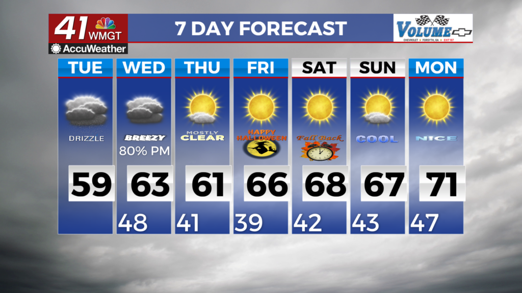
 air streaming in along the leeside of the Appalachians, this is contributing to the raw-feeling conditions. A swath of moisture out ahead of a closed low advancing eastward has supported showers and a couple of embedded thunderstorms. This is serving to strengthen the cool dome. Widespread rainfall totals of 1.5 to 2.5 inches have occurred in the past 24 hours, with locally higher amounts up to 3 to 4 inches for portions of Northeast Georgia. As a result of these factors, highs are expected to remain well below normal — in the upper 40s to mid-50s for areas within the wedge airmass. For South Central Georgia, highs will warm just a bit more, into the 60s. Precipitation chances continue to erode from the southwest to northeast beginning this afternoon, with more complete drying likely by daybreak. Periods of drizzle or perhaps an isolated light shower are possible, especially across the northern and eastern portions of the area. Despite a lack of more meaningful reinforcing rainfall, wedge conditions will linger throughout the day Tuesday due to the absence of an eroding mechanism. As such, looking for yet another day with comparatively cool highs in the 50s to lower 60s. Another round of rainfall is expected Wednesday into Thursday as a mid-to-upper level trough and closed low barrel eastward across the Southeast. This system will be more moisture-starved relative to the system that brought widespread rainfall Monday. The stronger forcing will also generate a stronger surface low, so frontal forcing could intensify rainfall locally. A reinforcing shot of cool air will follow this system, with lows in the lower to mid 40s on Thursday and upper 30s to lower 40s on Friday.