


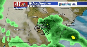
Cold front will bring isolated showers and thunderstorms today
MACON, Georgia. (41NBC/WMGT) – For an entire week, the Middle Georgia Regional Airport has tied or set a new record high temperature, but that streak will come to a close this afternoon.
TODAY.

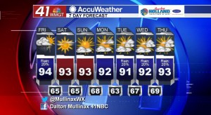
A cold front that has been slowly approaching our region will make it through Middle Georgia this afternoon and evening giving us a slight chance of seeing isolated showers and thunderstorms. Under a partly sunny sky this afternoon, temperatures will top out in the low to middle 90’s. The record high temperature for this day is 99° so we will not be close to that mark. Showers and a few thunderstorms will pop up this afternoon before dissipating after sunset. Overnight tonight temperatures will be hovering in the middle 60’s under a mostly clear sky.
WEEKEND.
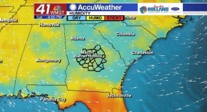
Behind the cold front we are going to see a little bit of drier air in place across the Peach State! On both Saturday and Sunday afternoon temperatures will top out in the low to middle 90’s under a sunny sky. By Sunday evening a weak cold front will move through our area giving us a very low chance of seeing an isolated shower.
NEXT WEEK.
We will start off the week on a dry note before weather afternoon showers and thunderstorms begin to pop back up later in the work week. Temperatures will be running about five degrees above normal in the low to middle 90’s.
 Follow Meteorologist Dalton Mullinax on Facebook (Dalton Mullinax 41NBC) and Twitter (@MullinaxWX) for weather updates throughout the day. You can also watch his forecasts Monday through Friday on 41NBC News at Daybreak (5-7 a.m.) and 41Today (11 a.m.).

Leave a Reply