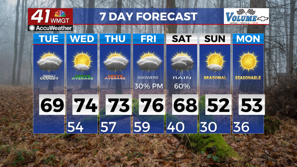
Clouds stick around as temps rise
MACON, Georgia (41NBC/WMGT) – Patchy dense fog continues to develop over much of Middle Georgia and some areas of Northwest Georgia. We are not expecting as widespread of an area as 


 we saw yesterday morning, but make sure you give yourself a little extra time in your travel commute. Zonal flow continues today into Wednesday with our next system off the west coast and a low pressure system over the Northeast. Prevailing southwest winds have resulted in enough moisture in the area to increase temperatures and dewpoints as we continue this stretch of above average temperatures for January. Any chance for isolated light showers could come overnight but that would be very slight. Winds could gust up to 20 mph today especially across the northern portions of Georgia in addition to cloudy skies. Temperatures today will reach into the upper 60s to low 70s which is about 15 degrees above normal. For Wednesday, highs in the low to mid 70s which could approach record highs. We are still eying the progression of a cut-off low in the southwest portion of the coverage area combining with a plunging polar shortwave and their interaction with the persistent ridging over the southeast. Models are showing uncertainty in the development of the resultant trough as well. One model (GEFS) suggests a slightly out of phase amplified wave which brings a cold front through the area overnight Friday, out of phase of peak heating. This is the widespread night time showers with a few storms scenario. Widespread severe unlikely. Scenario 2 will be a slower ejecting cut off low which will delay the arrival time of the trough. This would result in reduced forcing, however, the cold front arrival would lineup with daytime instability. Given temps near 70 in this set up and dewpoints near 60, this would be the less organized and isolated strong storm threat scenario. We will continue to monitor.