
Bring on the Heat: Warm Today, Rain Returns Tomorrow
MACON, Georgia (41NBC/WMGT) – Remember on Groundhog’s Day when both Punxsutawney Phil and General Beauregard Lee in Georgia saw their shadows and predicted six more weeks of winter? It doesn’t look like either of their forecasts will be very accurate this year.
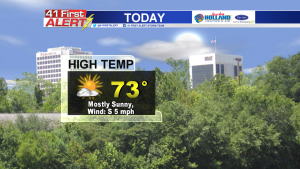
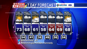
This winter has definitely been colder than last year, with strong fronts bringing arctic air down south. For the foreseeable future, temperatures will actually trend above average (60 degrees) in Middle Georgia. In fact, today’s highs will be in the low-mid 70’s.
What’s the reason for the unseasonably warm weather? A warm front attached to another low pressure system.
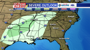
Out west, a low pressure system is making its way into the southeast. Ahead of the low, a warm front is developing over the gulf. This sector will aid in the development of isolated severe storms from east Texas to southwest Tennessee as warm, moist air moves in ahead of a cold front.
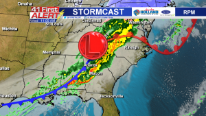
As the low shifts east, the cold front will come our way Wednesday. Rain is likely to enter Middle Georgia in the mid-morning hours and last through the bulk of the afternoon. Right now, there is no threat of severe weather in Middle Georgia Wednesday. Expect moderate to heavy rainfall, a few thunderstorms and gusty winds as the front rolls through.
Heading into Thursday, a temporary surface high will form and help clear out some of the left-over moisture from the low pressure system. The high will move over the Carolinas and more moisture will flow in from the Gulf. These air flows will keep moisture streaming over our area and rain chances in the forecast. Temperatures will stay mostly in the 60’s.
Connect with Meteorologist Kristen Kennedy on Facebook and Twitter for weather updates throughout the day. You can also watch her forecasts Monday through Friday on 41NBC News at Daybreak (5-7 a.m.) and 41Today (11 a.m.).


Leave a Reply