Another very warm day before rain arrives
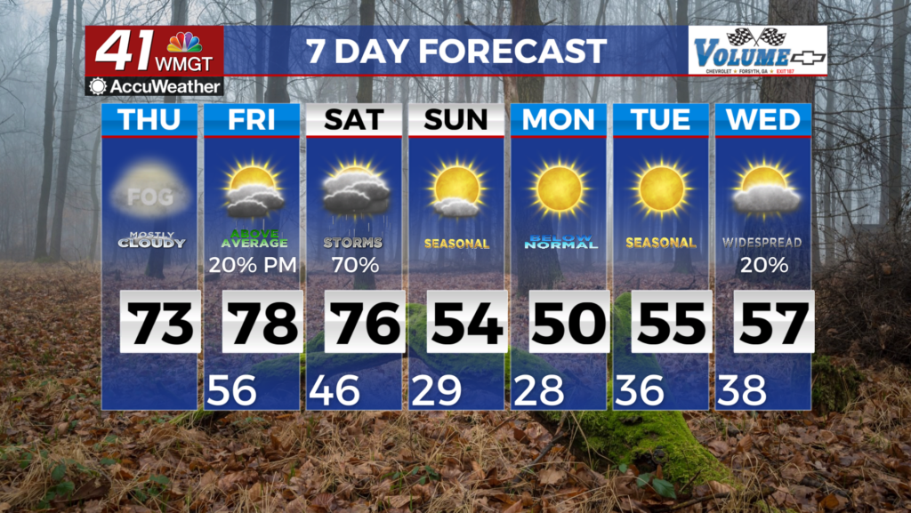


 MACON, Georgia (41NBC/WMGT) – In the short term, the forecast remains unchanged, however, things are about to quickly change beginning Friday evening.
The current satellite loop shows mid to high level clouds streaming across the area as moisture continues to get pumped in from the west to southwesterly flow.
The overall flow becomes more east to southeast today ahead of the next frontal system that moves into the area Friday.
With Atlantic moisture moving in over the region we could see an isolated shower or two Thursday night mainly across north Georgia. No thunderstorms are expected Thursday night.
Expect very warm temperatures for this time of the year. High temps for Thursday will be in the upper 60s and 70s. Lows tonight will mainly be in the upper 40s and 50s. Confidence continues to grow in seeing heavy rainfall impacting areas from northern Alabama into eastern Tennessee and far north Georgia on Friday evening into Saturday.
A fairly strong wave over the 4 corners region on Friday will eject slowly into the southern Plains and interact with another shortwave diving in from the Arctic into the northern Plains. A broad area of lift sets up across the southeast as moisture comes surging into the area from the Gulf. This means heavy rain for the region.
The Storm Prediction Center continues to maintain a Slight Risk (level 2 of 5) across far north Georgia, level 0 to level 1 for Middle Georgia.
Some flooding issues could occur in some locations. One more thing to mention is the possibility of seeing record highs Friday and Saturday. Highs will surge into the 70s and even into the 80s in parts of east Middle Georgia on Friday.
Overnight into Saturday morning, minimum temps may only dip into the lower 60s due to a combination of Warm Air Advection, moisture, and cloud cover.
This would break record minimums, however, this becomes a source of uncertainty as to how quickly the front progresses through the area.
On the same note, highs on Saturday will likely depend on where the front is through the afternoon and how much rain or storms are generated along the line. That will have big impacts on whether or not we reach any records.
In reference to the severe potential, it remains a conditional threat depending on how effectively the front can produce convection as it pushes through the area on Saturday.
The core of the upper level trough still remains well to the northwest meaning the upper levels are warm. So there is plenty of opportunity for a storm to get spicy under the right conditions.
After this system moves through, fake-spring ends and winter returns, although not with as much bite as previous encounters this season with the Arctic.
Lows on Saturday night drop into the 30s and 40s and highs on Sunday are in the 40s and 50s for most of the region.