Another dry day before rain arrives for the long weekend
MACON, Georgia (41NBC/WMGT) – Pleasant late summer weather continues again today as reinforcing dry air filters into Georgia. As surface high pressure slides east, a trough axis over the 


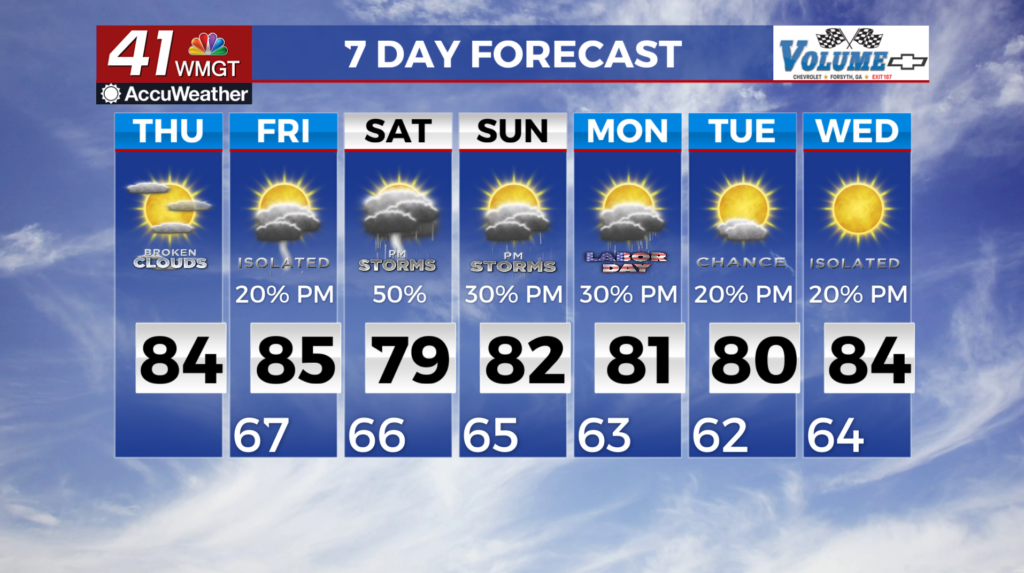
 eastern U.S. will guide a wave into the South/Southeast on Thursday. Expect increasing cloud cover through the day Thursday and a return of isolated to scattered showers over East Central Georgia by early Thursday evening. The bulk of the moisture, however, does look to hold off until the weekend. Temperatures will remain seasonable through the short term. Lingering clouds overnight Wednesday are expected to keep morning low temperatures a few degrees warmer than the crisp lows earlier Wednesday morning. Thursday and Friday minimum temps should largely be in the upper 50s to mid 60s. Highs are expected to be in the 80s. We are still running about 6 degrees below normal for this time of the year. Rain chances return overnight Thursday into Friday morning and shifting towards Middle Georgia into the weekend and early next week. The overall upper level pattern of the long wave trough over the Eastern U.S. will prevail but with shortwave impulses pushing a front into Middle Georgia over the weekend. Models have come a bit of a better agreement when it comes to rain chances. The overall thinking is that we will see some type of showers move into the area as a boundary sinks southward into Central Georgia. Rain chances as a result will push south into the Central Georgia area with daily diurnally driven showers and thunderstorms into midweek. We will see rain chances higher along Middle and southern Georgia but limited in northern Georgia. Temps will be the main story as the arrival of the secondary cold front will reinforce the cooler and drier air along with the high and low temps through the long term forecast. Highs in the upper 70s to low 80s can be expected with lows in the upper 50s to low 60s which are 3-7 degrees below normal.