

Another dry day before rain arrives for Sunday
MACON, Georgia (41NBC/WMGT) – Mostly clear skies are continuing across the area today. There is a dry back door front moving southwest through the region, however, all that’s happening 


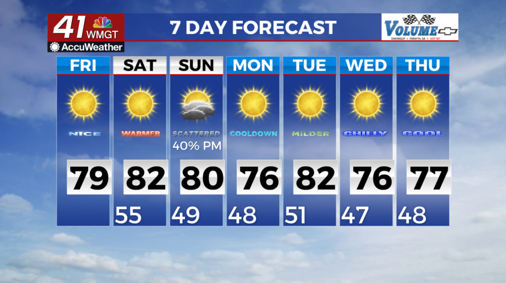
 is elevated easterly winds. This front is ushering in a building high pressure ridge centered over the eastern Great Lakes. This ridge center is expected to move into the Carolinas by Friday afternoon then push off the Georgia/South Carolina/North Carolina coast by Saturday morning. This ridge will bring in some slightly cooler daytime highs Friday but that’s all. Temperatures are expected to stay in the 70s and 80s with lows mainly in the 50s. Dry and warm conditions continue on Saturday as Georgia remains under the grasp of a ridge fleeting off to the east out over the Atlantic. This ridge is being pushed out by our next source of rain, a broad and deep trough that will be sliding across the Central U.S. As a result, winds over Georgia will turn out of the south to southwest on Saturday, strengthening overnight into Sunday morning as a shortwave within the trough shoots across the Mississippi and Tennessee Valleys. The surge of southwest flow brings increased moisture, combined with the shortwave will lead to scattered showers and thunderstorms across the area starting late Saturday night. By Sunday afternoon, the cold front associated with this system will start to push across Georgia from the west/northwest until it passes through and drier air begins to filter in. Any rainfall from this system will not make a dent in the drought conditions. Behind the front, high pressure and weak ridging moves over the region, with northwesterly flow ushering in cooler and drier air for Sunday night through early Tuesday morning.

