


Another cold & dry day before rain showers arrive
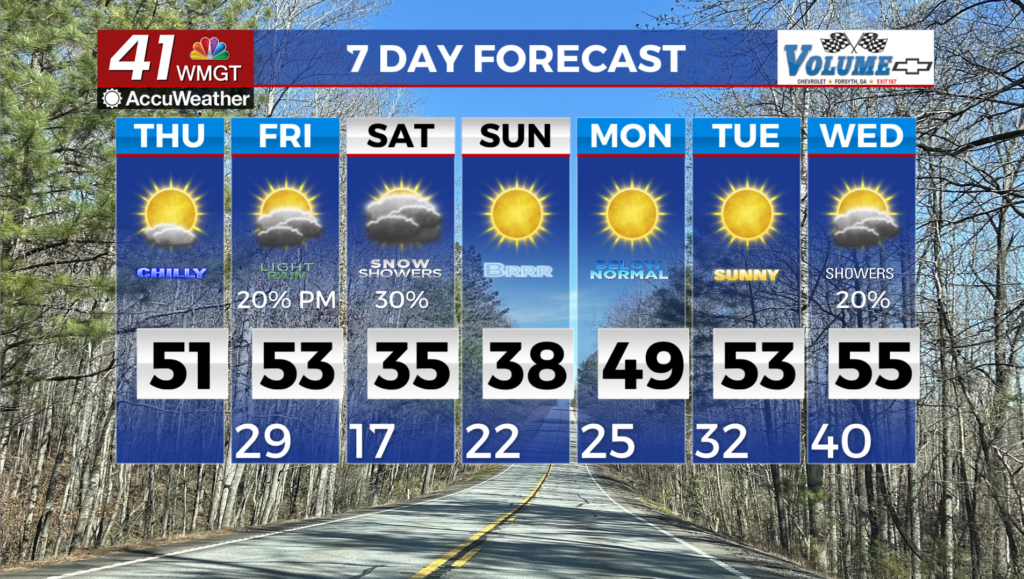
MACON, Georgia (41NBC/WMGT) – Cool and dry conditions continue again today under the influence of northwesterly flow and high pressure at the surface. A second push of dry air has 


nudged dewpoints into the teens and twenties across a wide area. Expect high clouds later this morning as moisture improves lift ahead of an approaching shortwave. Expect highs in the 40s to mid 50s, with lows tonight dropping into the upper 20s to low 30s. The extended forecast remains tricky for Friday through Sunday. Cold air rapidly moves into the area Friday night as an Arctic high descends out of the north. This will squeeze an upper level trough at the same time that shortwave energy ejects off the southern Rockies. Models are consistent on the interplay between the two systems. The problem comes from the sensitive surface conditions that may result. It will be difficult to determine which locations if any, receive snowfall in North and Central Georgia. Models have trended towards the west over the last few model runs which increases confidence in snowfall westward. The uncertainty plays out for the western 2/3 of the state. The major sticking points for the forecast will be the initiation of precipitation and the potential on the backside of the low. Several models are trending slower, bringing more moisture in ahead of the system which generally lead to a wetter first half. The models that move quicker end up developing a strong low which creates a more dynamic system leading to a back end snow potential as the main hazard. At this point, given the snow coverage across the Tennessee Valley, the colder and faster solution seems to have the slight edge in this situation. The result from this would be a quicker push of cold air and the development of snow across the north side of the surface low in northeast Georgia and western South Carolina. As the system moves eastward/ northeastward, strong northwest flow will drive wind gusts upwards to 30 mph for much of the area. Temperatures on the backside of the low will be frigid and wind chills could drop below zero Sunday morning! Temperatures may not squeeze past freezing until Monday morning with a slow temperature recovery, and no further precipitation expected.