

Above normal temps and an unsettled pattern start the weekend
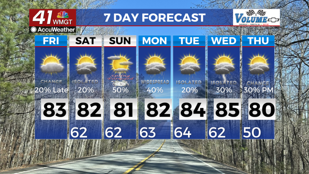
MACON, Georgia (41NBC/WMGT) – A warm and humid airmass remains locked in place across the area as a huge subtropical ridge expands westward from the Atlantic. This pattern will lead 


to continued temperatures well above seasonal norms with both lows tonight and tomorrow night and forecast highs on Saturday 15 to 20 plus degrees above normal. The fly in the ointment that could prevent record highs today will be the return of isolated to scattered diurnally-enhanced showers and thunderstorms within the deep southerly flow around the western side of the ridge. Models Friday afternoon support some thunderstorm activity although the lack of support will prevent notable severe concerns. Still, within this summer-like airmass, a couple of storms could produce gusty winds and brief heavy rainfall as they push north-northeastward. Coverage will then gradually decrease late Friday evening into Friday night. Over the course of the extended forecast, much of the Southeast will be dominated by the western edge of a subtropical ridge at the surface. A steady stream of warm, moist south-southwesterly flow will support unseasonable warmth through at least next Wednesday, along with truly summer-like chances for daytime-enhanced showers and thunderstorms each day. Any disturbances moving around in the mid-level flow will increase the coverage of showers and thunderstorms beyond the typical summertime distributions. Over the course of the day Saturday, a broad cold front sweeps across the Eastern U.S. , bringing with it weakly bolstered storms. The primary concerns with these storms would be for isolated damaging wind gusts in any stronger, more weakly organized clusters.