Above normal temperatures for another day, then a cool down
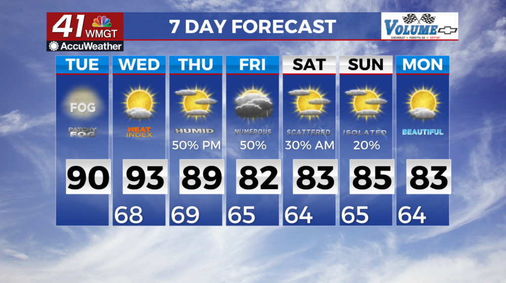
MACON, Georgia (41NBC/WMGT) – Isolated thunderstorms are expected along and north of I-85 between 3 PM and 9 PM Tuesday. Where convection develops it has to survive and pull energy 


 from a marginal environment. Wind shear will be nonexistent and this will hinder the ability of storms to organize and maintain themselves. At this time we don’t expect much more than a few lightning strikes and maybe an isolated downburst wind gusts near 35 mph. Afternoon high temperatures should rise by 1 to 4 degrees compared to Monday’s values. Widespread temps in the low 90s are expected in Middle Georgia (Macon and Columbus), while north Georgia will get a mix of upper 80s and lower 90s. These numbers are above normal, coming in at 6 to 12 degrees above seasonal averages. Wednesday will start off with continued hot, humid, and rain-free conditions, aside from some isolated afternoon showers or storms in Northwest Georgia. High temperatures will again be in the upper 80s to low 90s, with heat index values in the low to mid 90s in north Georgia, and upper 90s in central Georgia. A large shift in the pattern will start to take place late Wednesday as a potent stacked low moves into the Midwest and Ohio Valley. From Wednesday night through Thursday, significant moisture advection downstream of the low will spread across the state. This will support multiple rounds of showers and thunderstorms across the area through most of Friday, before a cold front associated with the low pushes through late Friday. Some strong storms are possible, but widespread severe weather is not expected at this time.