

Above normal temperatures could threaten records
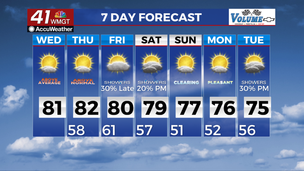
MACON, Georgia (41NBC/WMGT) – Despite some morning cloud cover high temperatures will lean heavily towards unusually warm numbers on Wednesday. Widespread afternoon highs that 


 are 12 to 18 degrees above average will still remain in our forecast. This translates to the upper 70s in North Georgia and lower 80s in Middle Georgia. Cities such as Atlanta and Athens should be within 2 to 4 degrees of record highs Wednesday afternoon. Macon and Columbus should approach record highs as well, although the odds suggest we won’t break these records due to morning cloud cover. The extended forecast starts off with weak ridging keeping things dry but that will be short-lived. High pressure centered off the South Carolina/Georgia coast keeps a warm frontal boundary north of the state through early Friday morning. This ridging allows temperatures to reach into the upper 70s to lower 80s across much of the area Thursday and Friday. We will be on the lookout for record breaking daytime highs, with some cities either forecasted to break, tie, or approach records. Temps are expected to be 15-20 degrees above seasonal norms. By Thursday afternoon, the next frontal system develops over the Southern Plains as a closed low center deepens over Northern Texas and Oklahoma through Friday morning. Its associated cold front will push into the lower Mississippi River Valley Thursday night with the deeper moisture reaching Northwest Georgia shortly after sunrise Friday. Warm moist southwest flow sets up ahead of this frontal boundary will also help increase daytime temps Friday. Showers will begin to push into Northwest Georgia around midday slowly moving southeast across the region through Saturday night. We should mainly see showers and isolated thunderstorms with this system. Expect some gusty winds along the front with any stronger storms however, we do not expect any severe weather. Things clear out once again for Sunday with increasing clouds again Monday ahead of the next frontal boundary developing across the Southern Plains.

