

A wet Easter for Middle Georgia
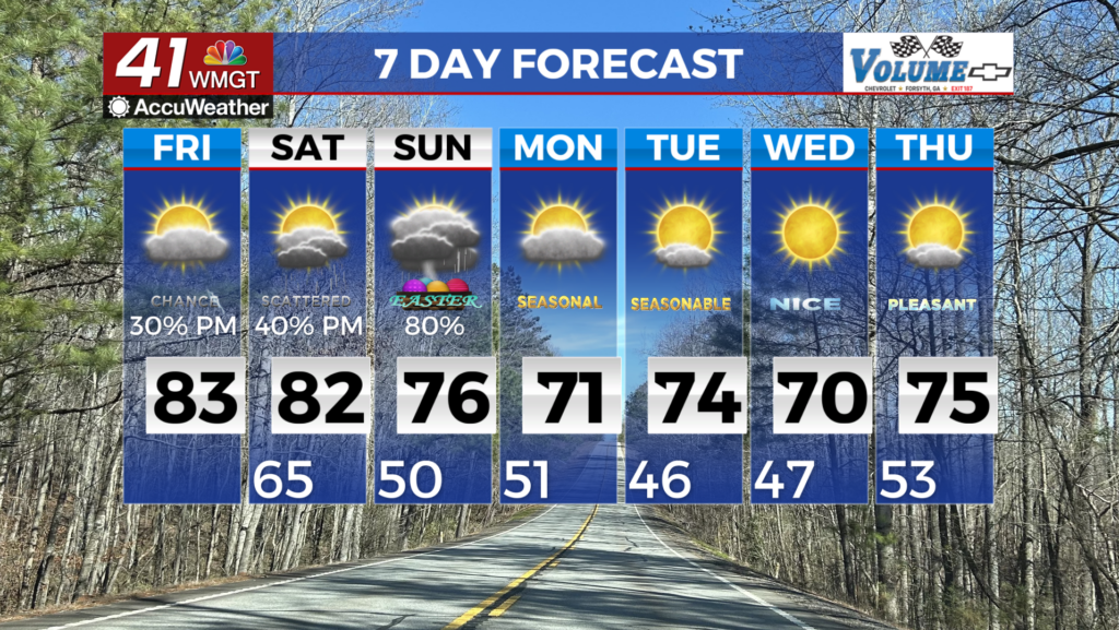
MACON, Georgia (41NBC/WMGT) – The Summer-in-April pattern continues today as the forecast area will remain along the western fringe of the Bermuda high. Temperatures will stubbornly 


remain at mid-May normal highs in the 80s and lows in the 60s, although record highs look to remain safe both today and Saturday. As far as any potential for much needed rainfall amid the ongoing and worsening drought, there will be no real prospect for improvement. The remainder of the afternoon and evening should bring a better chance of scattered showers and thunderstorms, particularly across the southern and eastern counties, as a weak trough lifts moisture northward. The extended period begins still under the influence of the Bermuda ridge but things change rather quickly as the frontal boundary moves south through the area Saturday night into Sunday. The forecast models have been very consistent with developing a frontal boundary over the central and southern Plains Friday night and pushing it into the lower Mississippi River Valley Saturday morning/afternoon. The cold front moves south and east pushing into Northwest Georgia on Sunday. Its easterly progression slows down a bit as it pushes into the Bermuda ridge but the models have been in great agreement showing this front moving southeast through the state Sunday and stalling somewhere between south Georgia and north Florida Monday. We are expecting diurnally-driven convection ahead of the front Saturday with showers and thunderstorms continuing across the area as the front moves through. Precipitation chances will be ending Sunday afternoon/evening. Upper level support is weak with this frontal passage therefore we are not expecting any severe weather. We are mostly looking for embedded lightning and gusty winds possible. After the front pushes through another ridge builds into the region from the northeast drying things out again. This second ridge sets up just off the New England coast and stays fairly stationary through the end of next week.