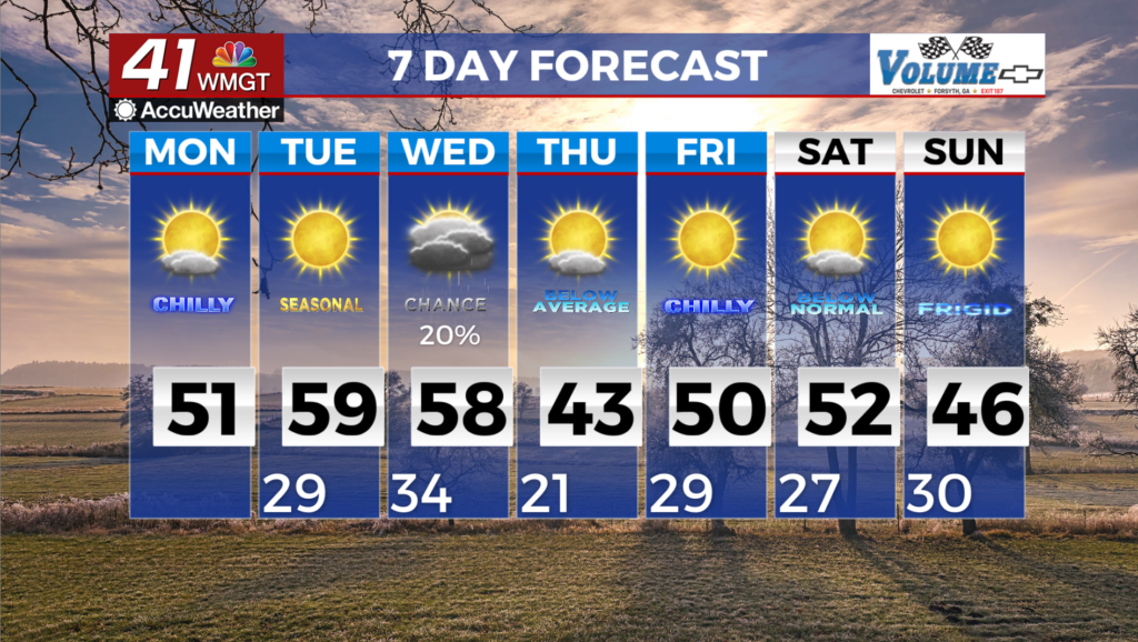
A return of cooler and more seasonal temps for Middle Georgia
MACON, Georgia (41NBC/WMGT) – Building high pressure results in mostly dry and noticeably cooler temperatures today. High cirrus clouds filtering in from the southwest might prevent 


 temperatures from really bottoming out however it will certainly feel quite chilly this morning. Morning lows will range from the upper 20s in North Georgia to the mid 30s across far South- Central Georgia. This afternoon temperatures will rise into the upper 40s to low 50s. Fire weather conditions are possible today, mainly across portions of East-Central Georgia, as drier air continues to filter into the region. We can anticipate drying of fuels today despite the high cirrus clouds that remain in the region. Relative humidity is forecast to drop below critical thresholds of 25 percent this afternoon and again on Tuesday. Light winds will help us both days but a Fire Danger Statement has been issued for low humidity and dry fuels in East-Central Georgia. Cloud cover clears out late tonight and temperatures will once again fall into the upper 20s to low 30s Tuesday morning. The high will gradually shift southward on Tuesday but dry weather is still expected. A brief warm up begins on Tuesday lasting into Wednesday with forecast highs rising into the 50s areawide. Fire weather will also be a concern due to low relative humidity across parts of South-Central Georgia during the afternoon.