
A half wet & half dry weekend for Middle Georgia
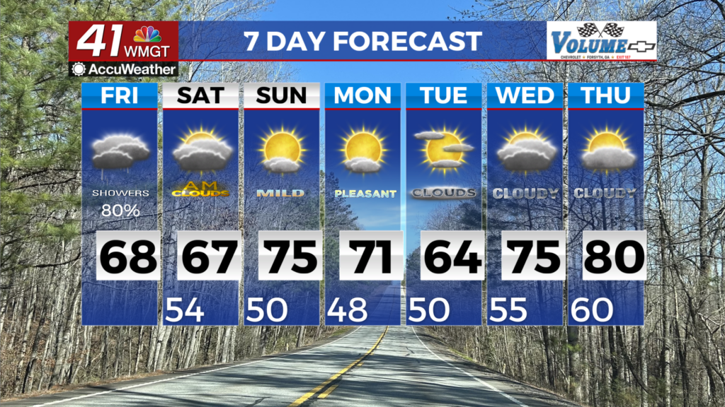
MACON, Georgia (41NBC/WMGT) – A line of showers and thunderstorms is actively pushing eats overnight into Friday morning. By sunrise, the shortwave starts to move across Georgia, with 


showers and storms focused along a slowly southward moving front over South Middle Georgia. Dry and stable air fills in on the backside of the shortwave throughout the day, with only a few lingering showers possible Friday afternoon across Georgia. Morning temperatures in the 50s will warm to the mid to upper 60s by the afternoon under mostly cloudy skies. At the start of the extended forecast on Saturday, the stalled or slowly moving boundary that supported a rainy end to the work week will have cleared North and Middle Georgia, setting the stage for dry conditions through the weekend. Unseasonable warmth continues with highs in the upper 60s to lower 70s on Saturday. Sunday will be even warmer, in the mid to upper 70s, with some locations within a degree or two of 80. By Monday, flow at the mid-levels becomes zonal, with a strong surface high moving into place across New England. As it does, characteristics of a wedge begin to spread southward along the Appalachians. Noticeably cooler air overspreads the typical wedge areas (generally north and east of the I-75/I-20 interchange), with strongest impacts on Tuesday. High temperatures will likely remain in the 50s within the wedge airmass, rising into the 60s to near 70 outside of it. Models suggest a front will approach the Tennessee River Valley from the west around the same time the wedge airmass builds in, and interaction between these two features may support rain chances through midweek next week.