

A cooldown to end the week
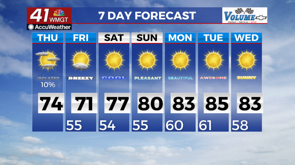
MACON, Georgia (41NBC/WMGT) A cold front continues to push through Georgia. Showers and isolated thunderstorms will continue along and ahead of the cold front, with rainfall largely 


 in portions of Middle Georgia. An additional pocket of light rainfall will be possible in northeast Georgia as a weak shortwave slides out of the Carolinas. Total rainfall with either feature should be light, with amounts in northeast Georgia limited to a couple hundredths of an inch to below a quarter of an inch. High pressure building over the Ohio Valley will drive a moderately strong wedge front through Georgia overnight. Behind the front cooler air and breezy northeast winds. Wind gusts in the 15 to 25 mph range are expected in north and Middle Georgia by sunrise on Thursday. The primary weather story for today will be the significantly cooler temperatures. Afternoon high temperatures should be 8 to 12 degrees cooler than Wednesday, with the change being driven by a combination of the cold front, wedge front, and cloud cover. Widespread afternoon highs in the 70s are expected, with elevations above 2500 feet in the mountains remaining in the 60s. An isolated shower could occur south of Macon in the morning, but the rest of the region will be dry. On Friday, high pressure will build down the eastern seaboard and pushing into northwest Georgia. A cooler, drier airmass moves in with this ridge. We are expecting cloud cover to diminish slowly through Friday night. There is also a wave along the tail end of the old front which begins to develop and becomes a closed low center just off the Georgia/Carolina coast by early Saturday morning. This low is expected to continue to develop as it moves up the eastern seaboard through Monday. This low center will wrap up quickly pulling what is left of the old frontal boundary northeast with it and allowing a drier airmass to filter into the state from the north/northeast. This will bring mostly clear skies and cooler Fall-like temps through Sunday.

