


A brief cooldown, then a warm up
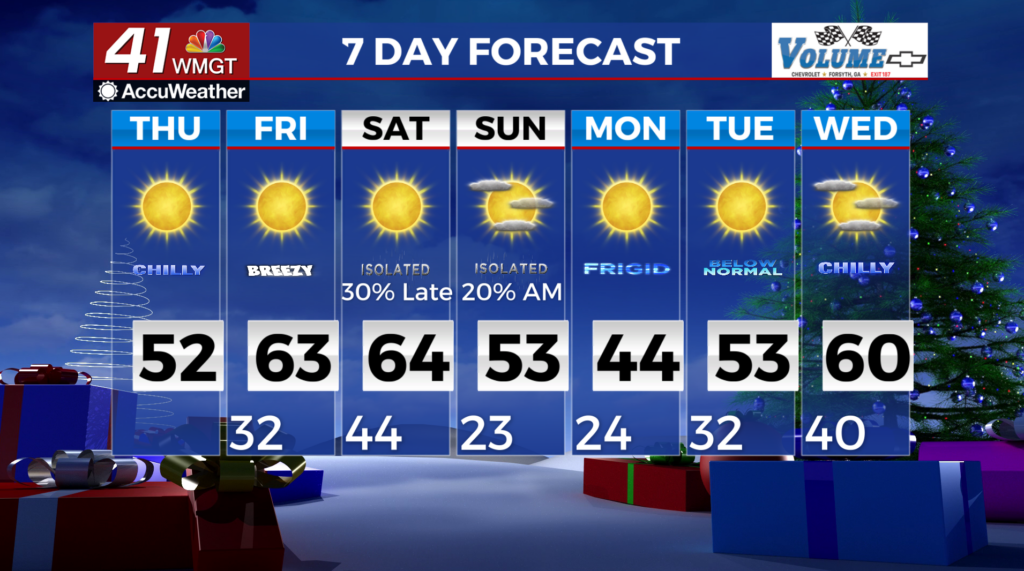
MACON, Georgia (41NBC/WMGT) – A post frontal airmass will be in place across Georgia today. High temperatures will be around 10 degrees cooler than yesterday due to cold air advection induced by northwest winds. A few gusts near 20 mph may occur this afternoon, however, weaker flow compared to yesterday should limit the wind gust potential today. 


 After a cool start Friday morning (morning lows in the lower 30s), temperatures will rebound quickly. Pressure gradients between a low in the Tennessee Valley and a high over Florida will produce modest southwest winds. This will push temperatures into the lower 60s across most of North and Middle Georgia by Friday afternoon. No precipitation or severe weather is expected Friday. For Friday night, broad troughing will remain in place across southeast Canada and the northeast U.S. Northwesterly upper level flow will be in place across the majority of the country behind this trough. Meanwhile, a closed midlevel low will drop from central Canada towards the Great Lakes region, with a surface low spinning underneath by Saturday morning. A second weak disturbance traversing the northwesterly flow and moving through the Tennessee Valley will only bring minimal forcing to north Georgia and is not expected to bring anything more than a light, isolated shower or two to the area overnight into Saturday. Lows on Saturday morning will be in the mid to upper 30s in north Georgia and low 40s in Middle Georgia. High temperatures will range from the mid 50s in the far northern tier to the upper 60s in east-central Georgia on Saturday afternoon. There is the potential for significantly colder air to set up behind the front late Sunday into early next week. The extent of how much temperatures will drop will depend on the movement of the high’s center and the proximity of north/Central Georgia is to the core of the coldest air. Latest guidance continues to trend towards a southeastward detour of the high’s center, through the Ohio Valley and across Georgia on Monday, then near the South Carolina coast early Tuesday. This would favor a greater drop in temperatures by early Monday morning. Also this same guidance also indicates the weakening of the high as it moves southeast, which would serve to moderate the airmass as it sets up over the region. At this time, lows on Monday are forecast to be mainly in the low 20s. We will continue to monitor the evolution and track of the Arctic high.