
A brief cooldown sets the stage for warmer days ahead
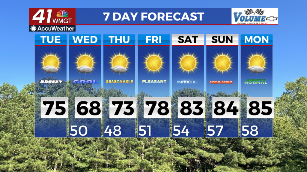
MACON, Georgia (41NBC/WMGT) – Parts of Southern Middle Georgia are under a Fire Weather Warning until 8 PM tonight. High pressure settles in over the course of the short term bringing 


cooler and drier conditions to much of the region. Temperatures are expected to be around seasonal levels with highs in the low to mid 70s and overnight lows in the 40s and 50s. Dewpoints behind this weekend’s cold front have dropped into the 30s and 40s and will stay there for the next 48 hours. Upper level split flow will be in place over much of the eastern U.S. through much of the forecast. On Wednesday, a ridge in the northern polar jet will move across the Great Lakes region towards New England. A strong surface high associated with the ridge will be centered near the New England coast, which will develop a wedge of cold air along the leeside of the Appalachians and into much of north and Middle Georgia. Winds within the wedge are expected to be east at 10-15 mph with gusts up to 25 mph. After the morning begins with lows in the upper 40s to low 50s, temperatures will reflect the wedge during the daytime, with highs being limited to the mid 60s to low 70s. With relative humidity values dropping to near 25 percent, and drying fuels, hazardous fire weather conditions will be possible once again on Wednesday afternoon. Wednesday night into Thursday, the ridge in the polar jet will move away to the northeast. As this occurs, the southern jet surges northward with another ridge setting up over the region. This will keep us under high pressure influence. The surface high meanders back to the southwest and becomes centered over Georgia. As the wedge and easterly flow weakens, temperatures will begin to moderate under the high on Thursday, rising into the low to mid 70s. As the subtropical ridge strengthens late in the week and into the weekend, temperatures continue to climb.