


A brief cool down, then extreme heat for the weekend
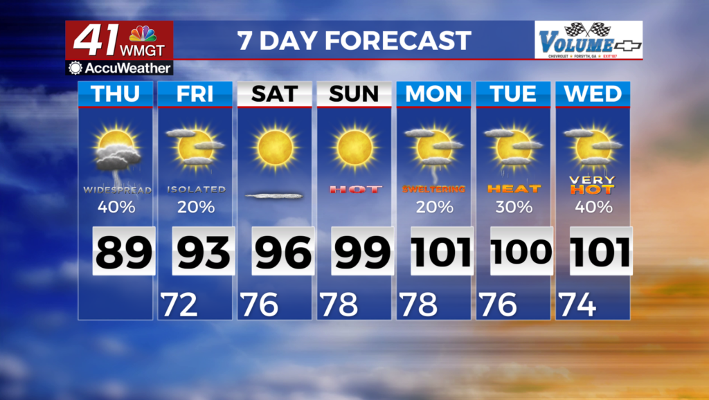
MACON, Georgia (41NBC/WMGT) – A ridge setup to the northwest is attempting to bridge over the top of a weak tropical wave located off the South Carolina coast. This system is extending  southwestward into the Gulf, and continues to rotate around another ridge. The wave positioned to the south/southeast is allowing a wedge front to drive southwestward from North Carolina/South Carolina into Georgia. Dewpoints have mixed down a bit, which is helping our feel-like temperatures. The circulation associated with the tropical wave will drift west and we will become situated on the southerly side of the wave. Models are suggesting a sea breeze front setting up this afternoon. Expect showers and storms particularly during peak heating hours towards sunset. Temps will be in the upper 80s with low to mid 90 heat indices. For Friday, a mid-level ridge sets up over the Southeast during the day, which will persist over the region over the weekend and into next week. Drier air or subsidence underneath the ridge will lead to lower rain chances starting Saturday, though isolated diurnally-driven thunderstorms are possible. The influence of this ridge will promote warming through the forecast period. High temperatures will rise into the mid to upper 90s over the weekend and into the upper 90s to low 100s on Monday through Wednesday.