
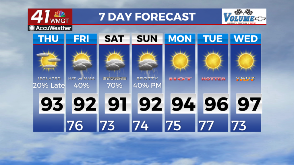
Monday’s rain will last the whole day
MACON, Georgia (41NBC/WMGT) — Compared to last week’s hot and dry weather, this week will consist of the total opposite: rainier weather, which in turn will keep temperatures down.
A southwesterly flow will keep rainfall moving into the area this week. As you can see from the picture of the radar, that’s where the rain will be coming, with widespread rain at first in the morning, then more on and off this afternoon and evening. Storm chances also increase this afternoon, but there’s no chance for severe weather. Just your garden variety spring thunderstorms.
Models are anticipating between 1 – 2 inches of rain during the next 48 hours. The rain will be less widespread tomorrow, but I am still putting our rainfall chances at around 70 percent due to rain persisting throughout the whole day on Tuesday.
Long-term models give us rain chances almost every day, though there is disagreement between two of our primary long-range models. The GFS (Global Forecast System) is a bit drier starting Thursday compared to the Euro model. Due to that, I’m keeping rain chances at 30 percent Thursday – Sunday as a heads up that the chance is there. There’s too much uncertainty to put the rain chances any higher, in my opinion.
Another thing to note: a cool dome of high pressure settles into the area Wednesday and Thursday, so barring overnight rain inflating our temperatures, the overnight lows to be cooler those two days. The highs will also be kept low in the low 70s and upper 60s.


Leave a Reply