Chilly overnights lead to seasonal afternoons
MACON, Georgia (41NBC/WMGT) – A Frost Advisory is out for northern Georgia, mainly along and north of I-85, as temperatures are expected to fall into the low 30s. Light and variable winds 


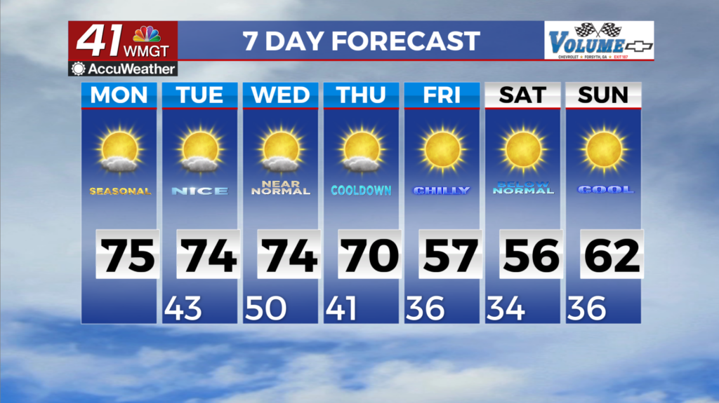
through the day will pick up Monday out of the northwest as a weak shortwave ushers some drier air in. Overnight lows will rebound Monday night into Tuesday. Temperatures will be moderated to the upper 30s and 40s as we start the work week. The extended forecast sees little in the way of change. The beginning of the week through Wednesday still looks to be warm as the upper level jet remains to the north of the area and our current air mass warms a bit thanks to copious amounts of sunshine. High temperatures Tuesday and Wednesday will be 5 to 10 degrees above average, 


which corresponds to temperatures in the 70s for most. Uncertainty remains going into Thursday regarding our rain chances. The ensemble trend for this forecasts period was to pull the main surface pressure falls further to the north across the average. Intensification of the jet streak within the trough are forecast to dig into the Eastern U.S. doesn’t happen in the meantime until after the axis pushes in overhead. Expecting short waves progressing through the western side of the trough, then phasing with the larger trough going into late Thursday night and Friday morning. The overall effect is to push any precipitation mostly across northern Georgia on Thursday afternoon and evening that would be associated with the push of the front into the area. The cold front pushes through the area into Friday. Forecast highs on Friday are 5-10 degrees below average, as it does look like the front will progress through most of all north and Middle Georgia by the afternoon. That brings us into the cooler days of the year so far, only getting into the 50s and the low 60s. A hard freeze is likely for portions of North Georgia Friday night into Saturday morning, and again on Saturday night into Sunday morning. Lows in North Georgia should be in the upper 20s, with low 30s into the metro and Athens and mid 30s into Middle Georgia.