One more dry and warm day before rain arrives
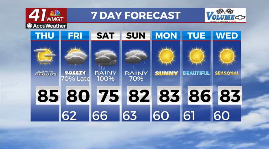
MACON, Georgia (41NBC/WMGT) – The calm weather is expected to continue through today and the first part of Friday for much of the area before Isaias leads to a change in weather conditions 


this weekend. Through early Friday we will see overall high pressure over the area with mostly light and variable winds. Temperatures will continue to rise to the low to mid 80s on Thursday which are about 10 to 12 degrees above normal. Lows will be in the mid to upper 50s Thursday morning and the upper 50s to low 60s on Friday morning. Mostly clear skies will begin to give way to high level clouds filtering in from the south on Friday. The extended period begins with precipitation from Isaias moving northward into Middle Georgia. The storm is now a hurricane and is centered due south of Mobile Bay across the Central Gulf. There is still some uncertainty with the intensity, track, and timing of the storm but things appear to be coming together for this system to 


make landfall near the Alabama/Florida border Saturday morning as a Category 1 or Category 2 hurricane. The current forecast track shows Isaias moving northward through Alabama Saturday with its remnant moving up into Kentucky and the Mid-Atlantic area through Sunday. As this system moves onshore the models have been very consistent showing the high pressure ridge over the Mid-Atlantic states setting up as a wedge down the Eastern Seaboard and into Northeast Georgia. This ridge/wedge will act as a steering mechanism and help to keep the center of Isaias to our west. This will put Georgia on the more active side of the storm with increased winds and rain expected across the state. Winds will ramp up Friday night with sustained winds in the 10 to 


to 15 mph range by daybreak Saturday. Sustained winds will continue to increase into the 15 to 20 mph range through Saturday afternoon with gusts up to 40 mph. The strongest winds will be across North and western portions of the state as the pressure gradient tightens between the ridge/wedge to the northeast and Isaias moving north through Alabama. Winds will begin to trail off Saturday night as the system weakens. By Sunday afternoon high pressure begins building back into the area as a developing ridge over East Texas becomes centered along the Mississippi/Alabama Gulf Coast. The exiting tropical system also begins to bring in some drier air from this ridge, clearing things out across Georgia through Sunday night. By Monday morning this ridge is expected to be centered over Central Alabama and should keep things warm and dry.