
Another warm day then a pattern shift
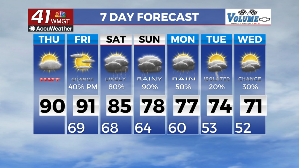
MACON, Georgia (41NBC/WMGT) – A mid-level ridge is in place over the Southeast continues to influence our calm weather over the short term. Expect to remain mostly rain-free with warm 


conditions continuing as high temperatures climb back into the mid to upper 80s to low 90s today. The daytime high temperatures will be about 8 to 10 degrees above normal. Winds will be light out of the southeast in the afternoon, working to bring dewpoint temperatures back into the upper 60s to low 70s later this afternoon for a good portion of Middle to South Middle counties. Expect patchy morning low clouds and fog across much of the area, Thursday morning before improving a few hours after sunrise. As the ridge begins to shift off the East Coast by late Thursday, expect a more robust southerly flow over the region. All in all, enjoy the last couple of days of mostly dry conditions before precipitation chances rapidly increase for late week and into the weekend. A 


pattern change is expected into late week to early weekend as we see moisture continue to spread into the area along with a frontal boundary pushing in over the weekend. Models are beginning to converge on a wet pattern for this weekend. Expect showers to begin on late Friday night and continuing through Monday morning with the main windows for heaviest rainfall likely between Saturday evening and Sunday evening. The spread will really come into play when it comes to rainfall amounts with this system. As we get closer to the event, the totals will come more into line with a rainy Saturday and Sunday. The factor in all of this and potentially higher totals will be the wedge. We are expecting the wedge to begin pushing into the area Saturday into Sunday which can be known to enhance rainfall totals in this area. Lightning is likely within the showers but it’s unlikely that we will see severe weather with this event. The setup is not conducive to a severe pattern. Temperatures will be a question on Saturday as models can struggle with the wedge pattern. Saturday and Sunday’s highs dominated by the wedge are likely to push below normal with mid 70s on Sunday. After this weekend, the front will push south relegating the rain chances to Middle Georgia for the week with temperatures remaining in the mid 70s through the week ahead.