

Cooler and wet Labor Day
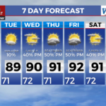
MACON, Georgia (41NBC/WMGT) – The frontal boundary from Sunday has allowed a cooler airmass to spread across the area overnight into Monday within east-northeast flow. This wedge-like 


pattern of breezy easterly winds and cloudy skies will make things feel much cooler than recent days, and high temperatures will struggle to get out of the low to mid 80s across most of the area. While the airmass will be cooler, the drier air will not move in until Monday night. We will likely still have enough forcing, moisture, and instability to support isolated to scattered rain showers or weak thunderstorms across the area. Tuesday through midweek, the core of midlevel ridging will move overhead, accompanied by high pressure at the surface oriented such that we’re likely to 


have an extended period of cold air damming (low level cold air mass is trapped at the surface or on the east side of mountain terrain). Heat begins to build once again, with highs returning to several degrees above average by mid-to-late week. Breezy easterly winds should support ample mixing during the afternoon, which will initially serve to keep heat index values within a few degrees of air temperatures. Convective development will be hampered by subsidence across the northern half of the area, with scattered to numerous showers and thunderstorms possible across south Middle Georgia through Wednesday.